
Santo Antão, Cape Verde facts for kids
|
Nickname: Ilha das montanhas (island of the mountains)
|
|
|---|---|
 |
|

Santo Antão
Location in Cape Verde
|
|

Santo Antão
Location in Cape Verde
|
|
| Geography | |
| Location | Atlantic Ocean |
| Coordinates | 17°04′12″N 25°10′16″W / 17.070°N 25.171°W |
| Area | 785 km2 (303 sq mi) |
| Length | 42.8 km (26.59 mi) |
| Width | 24.0 km (14.91 mi) |
| Highest elevation | 1,979 m (6,493 ft) |
| Highest point | Tope de Coroa |
| Administration | |
| Concelhos (Municipalities) | Paul, Porto Novo, Ribeira Grande |
| Largest settlement | Porto Novo |
| Demographics | |
| Population | 38,200 (2019) |
| Pop. density | 48.66 /km2 (126.03 /sq mi) |
Santo Antão is a beautiful island in Cape Verde, a country made of islands in the Atlantic Ocean. It's the westernmost island in the group called the Barlavento Islands. Many people call it the "island of the mountains" because it has so many tall peaks!
About 38,200 people lived on Santo Antão in 2019. The biggest city on the island is Porto Novo, which is located on the south coast.
This amazing island was discovered a long, long time ago, in 1461 or 1462. A Portuguese explorer named Diogo Afonso found it, along with two other islands, São Vicente and São Nicolau.
Island Government
Santo Antão is divided into three main areas, like counties or districts, which are called municipalities. Each municipality has its own local government to help run things.
The three municipalities on Santo Antão are:
Images for kids
-
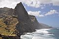
The beautiful coastline of Santo Antão.
-
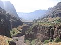
A view of Ribeira da Garça.
-
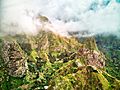
A stunning view of the mountains in Vale do Paúl, where you can see farms built on terraces.


More to Explore

Want to learn more in Spanish? Check out: Isla de Santo Antão para niños
