Saraguro facts for kids
Quick facts for kids
Saraguro
|
|
|---|---|
|
Parish and town
|
|

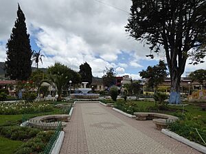
The main plaza in Saraguro
|
|
| Country | |
| Province | Loja Province |
| Canton | Saraguro Canton |
| Area | |
| • Parish and town | 75.85 km2 (29.29 sq mi) |
| • Town | 1.91 km2 (0.74 sq mi) |
| Population
(2022 census)
|
|
| • Parish and town | 9,679 |
| • Density | 127.607/km2 (330.50/sq mi) |
| • Town | 4,656 |
| • Town density | 2,438/km2 (6,314/sq mi) |
Saraguro (also called Sarakuru) is a town and a parish in Loja Province, Ecuador. It is the main town of Saraguro Canton. The Saraguro parish covers an area of about 75.85 square kilometres (29.29 sq mi).
The number of people living in the parish grew from 7,346 in 2001 to 9,045 in 2010. The town of Saraguro itself had 3,124 people in 2001 and 4,031 in 2010. Saraguro town is located high up in the mountains, at an elevation of about 2,719 metres (8,921 ft).
The Saraguro are an Indigenous group who are part of the Kichwa nation. They live in the southern highlands of Ecuador. They make up a big part of the population and culture of Saraguro town and canton. Another large group of people living here are mestizos, who have mixed heritage.
The Saraguro people have special traditional clothing. Men often wear ponchos and white hats with black spots. These hats are now usually wide-brimmed and made of sheep's wool. They also wear espadrilles (a type of shoe). Women wear anacos (a type of skirt) and shawls, often in similar colors.
What is the Climate Like in Saraguro?
Saraguro has a mild climate, meaning it's not too hot or too cold. The weather stays fairly consistent throughout the year.
| Climate data for Saraguro, elevation 2,520 m (8,270 ft), (1961–1990) | |||||||||||||
|---|---|---|---|---|---|---|---|---|---|---|---|---|---|
| Month | Jan | Feb | Mar | Apr | May | Jun | Jul | Aug | Sep | Oct | Nov | Dec | Year |
| Mean daily maximum °C (°F) | 18.2 (64.8) |
18.2 (64.8) |
18.1 (64.6) |
18.2 (64.8) |
17.7 (63.9) |
17.3 (63.1) |
17.3 (63.1) |
17.6 (63.7) |
17.7 (63.9) |
18.2 (64.8) |
18.3 (64.9) |
18.6 (65.5) |
18.0 (64.3) |
| Mean daily minimum °C (°F) | 9.3 (48.7) |
9.3 (48.7) |
9.3 (48.7) |
9.1 (48.4) |
9.1 (48.4) |
8.8 (47.8) |
8.8 (47.8) |
8.6 (47.5) |
8.8 (47.8) |
9.1 (48.4) |
9.0 (48.2) |
9.0 (48.2) |
9.0 (48.2) |
| Average precipitation mm (inches) | 68.0 (2.68) |
107.0 (4.21) |
114.0 (4.49) |
90.0 (3.54) |
48.0 (1.89) |
52.0 (2.05) |
43.0 (1.69) |
35.0 (1.38) |
40.0 (1.57) |
59.0 (2.32) |
56.0 (2.20) |
68.0 (2.68) |
780 (30.7) |
| Source: FAO | |||||||||||||
The average high temperature is around 17 to 18 degrees Celsius (about 63 to 65 degrees Fahrenheit). The average low temperature is around 8 to 9 degrees Celsius (about 46 to 48 degrees Fahrenheit).
Saraguro receives a good amount of rain throughout the year. The wettest months are usually February and March. Even in the drier months, there is still some rainfall. This steady rainfall helps keep the area green and fertile.
See also

- In Spanish: Saraguro (ciudad) para niños
 | George Robert Carruthers |
 | Patricia Bath |
 | Jan Ernst Matzeliger |
 | Alexander Miles |


