
Sargasso Sea facts for kids

The Sargasso Sea is a special area in the middle of the North Atlantic Ocean. It's part of a huge swirling system of ocean currents called a gyre. What makes it unique is that it's the only "sea" on Earth that doesn't touch any land! Instead, it's surrounded by four strong ocean currents.
These currents are the Gulf Stream to the west, the North Atlantic Current to the north, the Canary Current to the east, and the North Atlantic Equatorial Current to the south. Together, they create the North Atlantic Gyre. All the things these currents carry, like marine plants and even trash, often end up floating in the Sargasso Sea.
Contents
Location and Unique Features
The Sargasso Sea is very large. It stretches about 1,100 kilometers (700 miles) wide and 3,200 kilometers (2,000 miles) long. The island of Bermuda is located near its western edge.
The water in the Sargasso Sea is known for being a beautiful deep blue color. It's also incredibly clear, meaning you can see very far underwater, sometimes up to 60 meters (200 feet)!
How the Sargasso Sea Got Its Name
Sailors from Portugal were among the first Europeans to explore this region in the 1400s. They noticed a lot of a specific type of seaweed floating on the surface. This seaweed is called Sargassum.
Because there was so much of this seaweed, the sailors decided to name the area after it. That's how it became known as the Sargasso Sea.
Amazing Animal Journeys
The Sargasso Sea is a very important place for the migration of several amazing sea creatures.
Eel Life Cycle
Both the European eel and the American eel begin their lives here. Their tiny, see-through babies, called larvae, hatch in the Sargasso Sea. These larvae then travel thousands of miles across the ocean. Some go to Europe, while others head to the East Coast of North America.
Later in their lives, when they are ready to lay their own eggs, these adult eels make the long journey back to the Sargasso Sea. It's a truly incredible round trip!
Loggerhead Sea Turtle Nursery
Young Loggerhead Sea Turtles also use the Sargasso Sea as a safe haven. After they hatch, these baby turtles use ocean currents, like the Gulf Stream, to reach the Sargasso Sea.
Once there, they hide among the thick mats of Sargassum seaweed. This seaweed provides excellent cover, protecting them from predators until they grow bigger and are ready to venture into the open ocean.
Images for kids
-
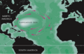
Map of the Sargasso Sea
-
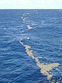
Lines of sargassum in the Sargasso Sea


See also
 In Spanish: Mar de los Sargazos para niños
