
Sarju facts for kids
Quick facts for kids Sarju |
|
|---|---|

Sarju River
|
|
| Other name(s) | Kumaoni: सरज्यू, Hindi: सरयू |
| Country | |
| State | Uttarakhand |
| region | Kumaon |
| Physical characteristics | |
| Main source | Sarmul, 15 km south of Nanda Kot 3,000 m (9,800 ft) 30°7′58″N 80°1′56″E / 30.13278°N 80.03222°E |
| River mouth | Sharda River, Uttarakhand, India 429 m (1,407 ft) 29°26′38″N 80°14′33″E / 29.44389°N 80.24250°E |
| Length | 130 km (81 mi) |
| Basin features | |
| Tributaries |
|
The Sarju river, also called Sarayu, is a very important river in the Kumaon region of Uttarakhand, India. It starts in a place called Sarmul and flows through towns like Kapkot, Bageshwar, and Seraghat. The Sarju then joins the Mahakali River at Pancheshwar.
This river is the biggest branch of the Sharda River. It also forms the border between the Pithoragarh and Almora areas. The land around the Sarju River is covered with beautiful forests.
Contents
What's in a Name?
The name "Sarju" comes from an old Sanskrit word, sar. This word means "to flow." So, Sarju basically means "the one that flows."
Where the Sarju River Flows
The Sarju River begins at Sarmul in the northern part of the Bageshwar district in Uttarakhand. Its source is high up on the southern side of a mountain ridge near Nanda Kot.
The river first flows about 50 kilometers (31 miles) southwest through the Kumaon Himalayas. Along this path, it meets smaller rivers like Kanalgadh and Punger. A bit further downstream, the Lahor river joins it.
Then, the Sarju turns south and flows through the city of Bageshwar. Here, another important river, the Gomati, joins it.
The Sarju continues for about 65 kilometers (40 miles) mainly southeast. Many streams from the Gangoli region flow into it from the left side. From the right, several streams from the Chaugarkha region also join, including Gatgadh and Panar. A small river called Jaingan joins the Sarju at Seraghat.
About 20 kilometers (12 miles) before it ends, the Ramganga river meets the Sarju at Rameshwar. Finally, the Sarju reaches Pancheshwar at the border with Nepal, where it joins the Sharda River. The Sarju travels a total of 130 kilometers (81 miles).
River Branches
The Sarju River has several smaller rivers that flow into it. These are called tributaries.
Gomati River

The Gomati river starts in the higher areas of Bhatkot. It joins the Sarju River in Bageshwar. The Gomati flows through the Katyur Valley, which is a big farming area in Kumaon.
Kuloor River
The Kuloor river begins near the Bhadrkali Temple. It flows through places like Rawatsera and Ganai Gangoli before joining the Sarju at Seraghat.
Punger River
The Punger river starts near Sangar village. It joins the Sarju from the left side at Sartana.
Lahor River
Lahor is a small river that flows into the Sarju from the right side.
Panar River
The Panar river starts on the northern slopes of the Mornaula Range, southeast of Almora. It joins the Sarju near Rameshwar.
Ramganga River
The Ramganga East is the largest river that flows into the Sarju. It starts from the Namik Glacier in Pithoragarh district of Uttarakhand. The Ramganga flows southeast and is fed by many smaller rivers. It finally joins the Sarju River at Rameshwar.
Sarju in Old Stories
The Sarju River is mentioned many times in the ancient Indian epic story, the Ramayana. In the story, the Sarayu (which is another name for the lower Ghaghara River) flows through the city of Ayodhya. Ayodhya is known as the birthplace of the Hindu god Rama.
According to the legend, Rama and the people of Ayodhya went to a heavenly place called Vaikuntha by entering this river. It is also believed that Urmila, who was the wife of Lakshmana (Rama's brother), found peace by entering the Sarju River.
Sarju in Books
The Sarayu is also the name of a river in the fictional town of Malgudi. This town was created by the famous Indian writer R. K. Narayan.
In the book "The Shack" by American writer William P. Young, Sarayu is the name given to the Holy Spirit.
Images for kids
-
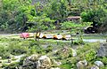
Camping on saryu river
-
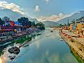
Saryu river at Bageshwar
-
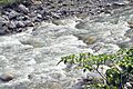
Close-up view of Sarju water flowing
-
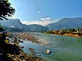
Saryu river at Bageshwar
-
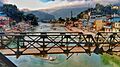
Suspension Bridge over Saryu river at Bageshwar


See also
 In Spanish: Sarju para niños
