
Sattley, California facts for kids
Quick facts for kids
Sattley
|
|
|---|---|
 |
|

Sattley, California
Location in California

Sattley, California
Location in the United States
|
|
| Country | |
| State | |
| County | Sierra |
| Area | |
| • Total | 2.049 sq mi (5.307 km2) |
| • Land | 2.047 sq mi (5.303 km2) |
| • Water | 0.002 sq mi (0.005 km2) 0.09% |
| Elevation | 4,947 ft (1,508 m) |
| Population
(2020)
|
|
| • Total | 44 |
| • Density | 21.47/sq mi (8.29/km2) |
| Time zone | UTC-8 (Pacific (PST)) |
| • Summer (DST) | UTC-7 (PDT) |
| Area code(s) | 530 |
| GNIS feature IDs | 232594; 2583131 |
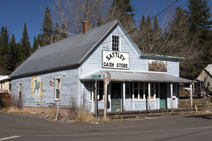
Sattley is a small community in Sierra County, California, United States. It is known as a census-designated place, which means it's a special area set up by the government for counting people. Sattley was once called Church's Corners.
You can find Sattley southwest of Loyalton. It sits right on California State Route 49 and California State Route 89. The community was named after Harriet Sattley Church, a local resident. A wealthy prospector named Eric Amen founded the town in 1881. The first post office in Sattley opened a few years later, in 1884.
Where is Sattley Located?
Sattley is a small area covering about 2.0 square miles (5.3 square kilometers). Most of this area is land, with a tiny bit of water. It's nestled in the beautiful Sierra County, California.
Who Lives in Sattley?
In 2010, the United States Census counted 49 people living in Sattley. These people lived in 25 different homes. About 16% of these homes had children under 18 years old. Most people in Sattley own their homes.
The population is spread out in terms of age. There are people of all ages, from kids to seniors. The median age in Sattley was about 48.8 years old.
See also
 In Spanish: Sattley (California) para niños
