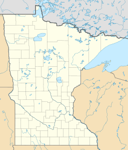
Savage Lake facts for kids
Quick facts for kids Savage Lake |
|
|---|---|
| Location | Ramsey County, Minnesota |
| Coordinates | 45°1′12″N 93°5′30″W / 45.02000°N 93.09167°W |
| Type | lake |
| Surface area | 17.4 acres (7.0 ha) |
| Max. depth | 5.9 feet (1.8 m) |
Savage Lake was once a lake located in Ramsey County, Minnesota, in the U.S. state of Minnesota. Today, it is mostly a wetland area. This change happened because of a major highway project.
What is Savage Lake Now?
Savage Lake is no longer a typical lake. It is now called a "watershed" area. A watershed is a land area that collects and drains water into a specific body of water.
The lake was split into two parts by the I35E highway in the 1970s. These two parts are called the eastern and western basins. They are connected by a pipe. Water flows from the western part into the eastern part.
Even though it's called a lake, Savage Lake is actually a 27 acres (11 ha) wetland. Wetlands are areas where water covers the soil, or is present near the surface, for all or parts of the year.
Size and Depth
The western part of Savage Lake is 17.4 acres (7.0 ha) in size. Its deepest point is about 5.9 feet (1.8 m). The eastern part is smaller, at 9.6 acres (3.9 ha). Its maximum depth is around 5.7 feet (1.7 m).
How Savage Lake Changed
Before 2009, Savage Lake was deeper. It was fed by natural springs, which kept it full of fresh water. However, a big change happened during an expansion of the I35E freeway.
The state's Department of Transportation decided to dump dirt and other road materials into the lake. This was part of the freeway project. Within a few weeks, the natural springs that fed the lake became blocked by this dirt. As a result, the lake started to fill up and become shallower. This is why it is now mostly a wetland.
Why the Name "Savage"?
Savage Lake was named after the native people who lived in the area long ago. The word "savage" was an old term sometimes used to describe them. This name reflects the history of the region.
 | Laphonza Butler |
 | Daisy Bates |
 | Elizabeth Piper Ensley |


