Sawyers Bay facts for kids
Quick facts for kids
Sawyers Bay
|
|
|---|---|
|
Suburb
|
|

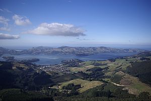
Sawyers Bay seen from Mt Cutten
|
|
| Country | New Zealand |
| Local authority | Dunedin |
| Area | |
| • Land | 229 ha (566 acre) |
| Population
(2018 Census)
|
|
| • Total | 1,095 |
|
|
||
Sawyers Bay is a small town, called a suburb, near the city of Dunedin in New Zealand. It's about 1.5 kilometers (1 mile) southwest of Port Chalmers. It sits in a wide valley right by Mussel Bay, which is part of Otago Harbour. Dunedin city center is about 13 kilometers (8 miles) away to the southwest.
Sawyers Bay is on the western side of Otago Harbour. It's located between two rocky points: Port Chalmers to the east and Roseneath to the west. The main rail line for the South Island and State Highway 88 both run along the edge of the bay.
Contents
What's in a Name?
The name Sawyers Bay gives a clue about the first people who lived here. Many early settlers were "sawyers," meaning they cut down trees for wood. This area provided a lot of timber. This wood was used to build things in both Dunedin and Port Chalmers. Today, most of the old timber businesses are gone. Sawyers Bay is now mostly a place where people live.
Roads and Routes
The main living area of Sawyers Bay is built around one long street. This street starts near the bay and goes inland. Near the coast, it's called Station Road. Further inland, it becomes Hall Road.
At the coastal end, Station Road connects to State Highway 88. This highway runs along the west side of Otago Harbour. It connects Port Chalmers to Dunedin, passing through places like Saint Leonards and Ravensbourne.
Further inland from the main road, other streets branch off. One important street is Stevenson Avenue. It links to a back road to Port Chalmers (Borlases Road) on the east side. It also connects to Upper Junction Road on the west. Upper Junction Road is an old, winding road that used to go from North East Valley in Dunedin to Port Chalmers. It eventually joins the old Mount Cargill road, which was once the main road heading north out of Dunedin.
Local Features
Sawyers Bay has a few interesting spots. The Port Chalmers Golf Course is located in the northern part of the area. There's also a walking track called Grahams Bush. This track connects the end of Hall Road to the Mount Cargill road, offering a nice walk through the native bush.
The McLachlan family is a very old and well-known family in Sawyers Bay. Their family has lived here since before European settlers arrived. Today, many people in Sawyers Bay work in jobs related to the sea. There are also many firefighters living in the community.
How Many People Live Here?
| Historical population for Sawyers Bay | ||
|---|---|---|
| Year | Pop. | ±% p.a. |
| 2006 | 1,032 | — |
| 2013 | 996 | −0.51% |
| 2018 | 1,095 | +1.91% |
Sawyers Bay covers about 2.29 square kilometers (0.88 square miles). In 2018, about 1,095 people lived in Sawyers Bay. This was an increase of 99 people since 2013.
The people living in Sawyers Bay in 2018 included:
- 237 people (21.6%) were under 15 years old.
- 147 people (13.4%) were between 15 and 29 years old.
- 522 people (47.7%) were between 30 and 64 years old.
- 189 people (17.3%) were 65 years or older.
Most people (94.2%) were of European background (Pākehā). About 12.1% were Māori, and smaller numbers were Pasifika or Asian. Many people (60%) said they had no religion, while 30.4% were Christian.
Learning in Sawyers Bay
Sawyers Bay School is a primary school for children in Years 1 to 6 (ages 5 to 10-11). The school first opened in 1861. As of November 2023, it has 102 students.
 | Lonnie Johnson |
 | Granville Woods |
 | Lewis Howard Latimer |
 | James West |


