Schortens facts for kids
Quick facts for kids
Schortens
|
|||
|---|---|---|---|
 |
|||
|
|||
| Country | Germany | ||
| State | Lower Saxony | ||
| District | Friesland | ||
| Elevation | 6 m (20 ft) | ||
| Population
(2022-12-31)
|
|||
| • Total | 20,797 | ||
| Time zone | CET/CEST (UTC+1/+2) | ||
| Postal codes |
26419
|
||
| Dialling codes | 04421–23, 04461, 04468 | ||
| Vehicle registration | FRI | ||
| Website | www.schortens.de | ||
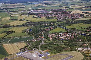
Schortens is a town located in the state of Lower Saxony, Germany. It is part of the Friesland district. The town is made up of 12 different areas, or districts. These districts are Schortens, Heidmühle, Grafschaft, Accum, Sillenstede, Schoost, Roffhausen, Middelsfähr, Addernhausen, Oestringfelde, Ostiem, and Upjever.
Schortens is known for its green spaces and its connection to the North Sea coast. It offers a mix of quiet living and access to larger cities.
Contents
What is Schortens Like?
Schortens is a town with a population of over 21,000 people. It sits at an elevation of about 6 meters (20 feet) above sea level. The total area of the town is around 68.67 square kilometers (26.5 square miles).
How is Schortens Governed?
Like other towns in Germany, Schortens has a local government. This government helps manage the town's services and future plans. The head of the town's administration is called the mayor. As of the last update, the mayor was Gerhard Böhling, who is an independent politician. This means he does not belong to a specific political party.
What Does the Mayor Do?
The mayor is like the chief executive of the town. They work with the town council to make decisions. These decisions affect things like schools, roads, parks, and local events. They also represent Schortens to other towns and regions.
History of Schortens
The area where Schortens is located has a long history. People have lived here for many centuries. The name "Schortens" itself has roots in old German words. Over time, small villages grew into the larger town we know today.
Early Settlements
The region was first settled by Germanic tribes. Later, during the Middle Ages, churches and farms were built. These early buildings formed the core of the districts that make up Schortens today. For example, the district of Sillenstede has a very old church.
Growth and Development
In more recent history, Schortens grew as industries developed. Its location near the coast and larger towns helped it expand. After World War II, many people moved to the area, further increasing its population.
Geography and Nature
Schortens is located in a flat region of Lower Saxony. This area is close to the North Sea. The landscape is often characterized by fields, small forests, and waterways.
Natural Areas Around Town
There are several natural areas near Schortens. These areas are important for local wildlife. They also provide places for people to enjoy nature. Many residents like to walk or cycle in these green spaces.
How Does the North Sea Influence Schortens?
Even though Schortens is not directly on the coast, it is close enough to be influenced by the North Sea. The climate is often mild and windy. The nearby coastal areas are popular destinations for day trips.
Education and Community Life
Schortens has schools for children of all ages. These schools help young people learn and grow. The town also has various clubs and organizations. These groups offer activities for different interests.
Sports and Recreation
Many sports clubs operate in Schortens. These clubs offer activities like soccer, handball, and gymnastics. There are also facilities for swimming and other recreational sports. These activities help keep the community active and healthy.
Local Events and Traditions
Throughout the year, Schortens hosts several local events. These events bring people together. They often celebrate local traditions or holidays. Such gatherings help build a strong sense of community among residents.
See also
 In Spanish: Schortens para niños
 | John T. Biggers |
 | Thomas Blackshear |
 | Mark Bradford |
 | Beverly Buchanan |


