
Sea Cut (Scalby Beck) facts for kids
Quick facts for kids Sea Cut (Scalby Beck) |
|
|---|---|

Scalby Beck (Sea Cut) meandering to its mouth at Scalby Mills
|
|
| Country | England |
| Counties | North Yorkshire |
| District | Scarborough |
| Physical characteristics | |
| Main source | Mowthorpe 41 m (135 ft) |
| River mouth | Scalby Ness Scalby Mills 0 m (0 ft) |
| Length | 8 km (5.0 mi) |
| Basin features | |
| Basin size | 32.126 km2 (12.404 sq mi) |
| Tributaries |
|
The Sea Cut (Scalby Beck) is a small river in North Yorkshire, England. It flows into the North Sea at Scalby Mills, near Scarborough. This river gets its water from local streams and other small rivers that drain from nearby hills. It also acts as a special channel for the upper parts of the River Derwent when there is a lot of flooding.
Contents
History of the Sea Cut
The Sea Cut gets its water from small streams and "becks" (another word for small rivers). These mostly drain water from the hills west of Scalby and Newby.
Why the Sea Cut Was Built
In 1799, the River Derwent had a very big flood. To stop this from happening again, a special channel was dug. This channel, called the Sea Cut, was built between Everley and Newby Bridge. Its main job was to prevent flooding in places like West and East Ayton.
The River Derwent usually flows about 150 miles (240 km) before it reaches the sea. But with the Sea Cut, floodwater can take a much shorter path to the North Sea. Important people like Sir George Cayley and William Chapman helped make this project happen.
The Sea Cut and the Ice Age
Long ago, during the Ice Age, water flowed to the sea along the path where the Sea Cut is now. But then, a lot of glacial mud built up. This mud caused the River Derwent to change its path. It started flowing west, away from the North Sea, instead of towards it.
Building the New Channel
The Sea Cut, also known as the New Cut, opened on September 3, 1804. It was about 3 miles (4.8 km) long and 9.1 metres (30 ft) wide. The water dropped about 41 metres (135 ft) along its length.
Workers built ten weirs (small dams) along the Sea Cut. These weirs help control the strong flow of floodwaters. A special gate at Everley helps direct floodwater into the Sea Cut when the Derwent is overflowing. This gate makes sure most floodwater goes down the Sea Cut, not into the Derwent.
Local business owners and farmers worked together to make this project possible. It also helped create more land for farming. A new bridge was built for Mowthorp Road as part of the plan. Other bridges in Scalby were replaced later, like Newby Bridge in 1890 and Whitby Road Bridge in 1906.
Monkey Island and the Sea's Edge
The Sea Cut's original exit into the North Sea was further south than it is today. There used to be a small island near the Sea Life Centre in Scarborough called Monkey Island. It was big enough for people to play cricket and football on it! The Sea Cut used to flow between the coast and Monkey Island. It then entered the sea further south, towards Peasholm. Over time, coastal erosion caused Monkey Island to disappear. Its remains were finally removed when the Scarborough Sea Life Centre was built.
The Sea Cut's Route

The Sea Cut starts near Mowthorpe Farm in the area of Suffield-cum-Everley. This is where the River Derwent turns south, away from the coast. The Sea Cut flows for about 3.1 miles (5 km) straight east. It passes over three weirs in this straight, dug-out section.
It flows under Mowthorp Road and then turns northeast. After this, it reaches Hackness Road. This is where the dug-out part ends. The last 1.9 miles (3 km) of the river is known as Scalby Beck. Historically, the river was called Scalby Beck from where Church Beck joins it.
The beck then flows under the A171 road at Newby Bridge. From here, it winds and turns more, as this is its natural path before the new cut was added. It then goes under an old railway bridge and the A165 road. Finally, it flows through a deep channel at Scalby Ness and into the North Sea. This happens by Scalby Mills and the Scarborough Sea Life Centre. The last part of the river has most of the weirs, with seven out of ten located here.
The Environment Agency is in charge of controlling floods and preventing them in the Sea Cut. This is because it's considered a main river, like the Derwent and other important rivers. The smaller streams that flow into the Sea Cut and Scalby Beck are looked after by Scarborough Borough Council.
Past Industries Along the Sea Cut
The Sea Cut and its banks were once busy with different industries. The most important were the four mills that stood along the beck. Two of these mills are still standing today. One is an old watermill from the 1600s, which is now a Youth Hostel on the A165 road. The other, Low Mill at Scalby Mills, is now a public house (a pub). It was changed from a mill by 1854.
High Mill and its buildings are still there as High Mill Farm. They are considered important historical buildings. People have been milling (grinding grain) at this spot since 1609. High Mill used the increased water flow from the Sea Cut to power its waterwheel. The channel that carried water to the wheel has since been filled in.
Another corn mill operated near Newby Bridge. It opened in the mid-1700s and closed by the 1950s. This mill received its corn by train at Scalby railway station.
Nature and Wildlife
When the Sea Cut was drained for repairs in 2014, about 100 Crayfish were moved to safety. They were put back into the beck after the repairs were finished.
Many things, especially the weirs, make it hard for fish to swim upstream in the beck. Steps have been taken to help with this problem. In 2012, a special fish pass was put on the weir near the Burniston Road Bridge (A165). The Scalby Beck Angling Club spent £9,000 on this wooden structure. It's like another successful fish pass already installed further up the beck.
Another challenge for fish is the weir at the mouth of the beck. There's a concrete pipe there that used to carry sewage. Except at high tide, it's very hard for fish to swim past this point.
Scalby Beck is the only important place where sea trout can lay their eggs between the River Esk at Whitby and the Humber Estuary. Otters have also been seen living along the beck. The lower parts of the beck are recognized as a Site of Importance for Nature Conservation (SINC). This means they are important for wildlife.
How to Visit the Sea Cut
In the upper parts of the Sea Cut, where it crosses flat land west of Scalby, you can walk or ride along paths on both sides of the river. The Tabular Hills Walk follows the southern bank from the A171 Road bridge to Mowthorpe Farm. This walk is about 48 miles (77 km) long and goes from Scalby Mills to Helmsley.
The lower parts of the Sea Cut, from the A171 Road to the mouth, are steeper. Access here is managed by the Scalby Beck Angling Club.
You can easily reach the mouth of the beck using a footbridge that is part of the Cleveland Way walking path. The mouth is also right next to Scalby Mills and the Scarborough Sea Life Centre, making it easy to visit.
Gallery
-
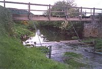
Sea Cut Weir, Suffield cum Everley; the Derwent is out of shot on the left. This view is looking north west.
-
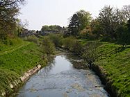
Sea Cut looking towards Scalby. The Tabular Hills Way is on the right.
-
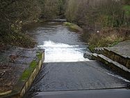
Weir on Sea Cut from A171 bridge looking east.
-
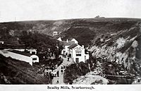
Scalby Mills, Scarborough North Yorkshire England 1901 - 1910 before the footbridge that carries the Cleveland Way was built.


