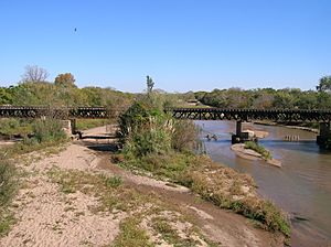
Segundo River facts for kids
The Segundo River, also known as Xanaes, is an important river in the central part of Córdoba Province, Argentina. It starts where two smaller rivers, the Los Molinos and Anizacate rivers, join together. This happens high up in the mountains, about 2,000 meters (6,560 feet) above sea level.
The river flows from west to east. Along its path, it forms a large lake at the Los Molinos Dam. This dam is used to create hydroelectricity, which is power made from moving water. After the dam, the river splits into two main branches. Both of these branches eventually flow into a big salt lake called Mar Chiquita, which is about 340 kilometers (211 miles) from where the river begins. On average, about 12.2 cubic meters (430 cubic feet) of water flow through the river every second.
Where the River Flows
The Segundo River is part of a larger river system in central Argentina. This system also includes the Primero River (also known as Suquía) and the Dulce River. Many towns and cities are located along the Segundo River.
Some of the cities you can find along its banks include:
- Río Segundo
- Pilar
- Villa del Rosario
- Tránsito
- Arroyito
- El Tío
- Concepción del Tío
- Marull
- Balnearia
- Altos de Chipión
These communities often rely on the river for water and other resources.
The Name Xanaes
The river has two names: Segundo River and Xanaes. The name Xanaes comes from the language of the Comechingones, who were Native American people living in this area long ago. For many years, the name Xanaes was almost forgotten.
However, in the 1980s, people started using Xanaes on maps again. Some believe this was done to make the area sound more interesting and attract tourists. Even so, most people who live near the river still call it the Segundo River.
See also
 In Spanish: Río Segundo (río) para niños
 | Aaron Henry |
 | T. R. M. Howard |
 | Jesse Jackson |


