Sensuntepeque facts for kids
Quick facts for kids
Sensuntepeque
|
|
|---|---|
|
Municipality
|
|

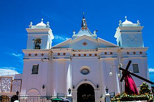
Santa Barbara Church
|
|
| Country | |
| Department | Cabañas Department |
| Founded | 1550 |
| Area | |
| • Total | 306.33 km2 (118.27 sq mi) |
| Elevation | 820 m (2,690 ft) |
| Population
(2012)
|
|
| • Total | 41,216 |
| • Density | 134.548/km2 (348.477/sq mi) |
| Postal code |
1201
|
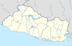
Sensuntepeque is a town and municipality in the Cabañas department of El Salvador. It is the main town and the capital of the department. Sensuntepeque is located about 83 kilometers (52 miles) northeast of San Salvador, the capital city. It sits at an altitude of 820 meters (2,690 feet) above sea level.
Contents
History of Sensuntepeque
The name Sensuntepeque comes from the local Pipil language. It means "400 hills," which describes the many hills in the area. The Lenca people were the first to live here.
Early Settlements and Independence
The town of Sensuntepeque was started as a Pipil people village in 1550. Later, in 1799, it became the main town for the area of Titihuapa. When the Spanish arrived, it became a village focused on religious activities.
On December 20, 1811, the people of Sensuntepeque stood up against Spanish rule. They declared independence in 1821. During the time of Governor José María Cornejo (1829-1832), Sensuntepeque officially became a town.
Later Events
In March 1871, the town was attacked. This happened when the country of Honduras declared war on El Salvador. Salvadorian Liberals, supported by the Honduran Army, raided the town.
By 1948, about 8,000 people lived in Sensuntepeque. During the Salvadoran Civil War in the mid-1980s, the road between Sensuntepeque and Ilobasco was very important. Soldiers patrolled this road daily to keep communications open.
Recent Developments
In 2013, the Archangel St. Michael Catholic School got new classrooms. Some older buildings were also fixed up. This project received help from the Japanese government.
Also in April 2013, street vendors in the city center moved to new market stalls. This move was needed because of new building projects. These projects included fixing the bus station and adding new street signs.
Geography and People
Sensuntepeque is located in northern central El Salvador. It is about 83 kilometers (52 miles) northeast of San Salvador. It is also about 27 kilometers (17 miles) northeast of Ilobasco. The town is on the southern side of Pelón mountain. It covers an area of 306.33 square kilometers (118.27 square miles).
Town Structure and Water
The area around Sensuntepeque is divided into 22 cantons and 236 rural villages. The town itself has four main neighborhoods, called barrios, and 28 smaller communities, called colonias.
There are several natural springs nearby. These include Catorce de Julio, La Mina, and El Chorro. Important places in the town are the Town Hall, a prison, several churches, and a park.
The population of Sensuntepeque is about 45,000 people today. This is a big increase from about 8,000 people in 1951. The city's water supply first came from the Catorce de Julio spring. Many other springs have been used since then to provide enough water for the growing city.
The beautiful scenery around the city attracts visitors. The road leading to Sensuntepeque winds through many hills and valleys.
Climate
Sensuntepeque has a pleasant climate. The weather information for the city is shown below.
| Climate data for Sensuntepeque (1991–2020) | |||||||||||||
|---|---|---|---|---|---|---|---|---|---|---|---|---|---|
| Month | Jan | Feb | Mar | Apr | May | Jun | Jul | Aug | Sep | Oct | Nov | Dec | Year |
| Mean daily maximum °C (°F) | 31.7 (89.1) |
33.2 (91.8) |
34.2 (93.6) |
34.3 (93.7) |
32.1 (89.8) |
30.9 (87.6) |
31.3 (88.3) |
31.3 (88.3) |
30.5 (86.9) |
30.1 (86.2) |
30.4 (86.7) |
31.1 (88.0) |
31.8 (89.2) |
| Daily mean °C (°F) | 22.9 (73.2) |
23.9 (75.0) |
24.8 (76.6) |
25.7 (78.3) |
25.1 (77.2) |
24.3 (75.7) |
24.2 (75.6) |
24.1 (75.4) |
23.8 (74.8) |
23.6 (74.5) |
22.9 (73.2) |
22.7 (72.9) |
24.0 (75.2) |
| Mean daily minimum °C (°F) | 15.5 (59.9) |
16.0 (60.8) |
17.2 (63.0) |
19.1 (66.4) |
20.1 (68.2) |
19.7 (67.5) |
19.0 (66.2) |
19.1 (66.4) |
19.3 (66.7) |
19.0 (66.2) |
17.1 (62.8) |
15.8 (60.4) |
18.1 (64.6) |
| Average precipitation mm (inches) | 2.5 (0.10) |
3.0 (0.12) |
18.6 (0.73) |
59.8 (2.35) |
257.9 (10.15) |
290.5 (11.44) |
282.5 (11.12) |
306.7 (12.07) |
375.2 (14.77) |
268.3 (10.56) |
62.5 (2.46) |
9.6 (0.38) |
1,937 (76.26) |
| Average relative humidity (%) | 75 | 72 | 71 | 74 | 82 | 86 | 85 | 86 | 88 | 87 | 82 | 79 | 80.8 |
| Source: Ministerio de Medio Ambiente y Recursos Naturales | |||||||||||||
Economy
In the past, during colonial times, the economy of Sensuntepeque was based on making indigo. Indigo is a plant used to create a blue dye.
Today, the main crops grown in the area include coffee, sugarcane, and grains. Another important crop is henequen, which is used to make fibers.
See also
 In Spanish: Sensuntepeque para niños
 | Claudette Colvin |
 | Myrlie Evers-Williams |
 | Alberta Odell Jones |


