Sharana facts for kids
Quick facts for kids
Sharana
ښرنه
|
|
|---|---|
|
City
|
|
 |
|
| Country | |
| Province | Paktika |
| District | Sharana |
| Elevation | 2,200 m (7,200 ft) |
| Population
(2010)
|
|
| • City | 5,929 |
| • Urban | 15,651 |
| Time zone | UTC+4:30 |
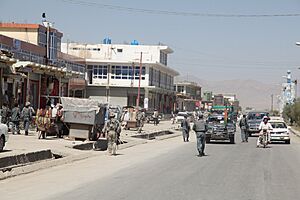
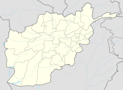
Sharana (Pashto: ښرنه) is an important city in Afghanistan. It is the capital of Paktika Province. Sharana is located high up in the mountains, about 2,200 meters (7,218 feet) above sea level.
In 2015, the city of Sharana had a population of about 15,651 people. It is known as a main area for the Sulaimankhel tribe, which is a part of the larger Ghilji group of Pashtuns. The city is divided into 6 smaller areas called districts. It covers a total land area of 5,893 hectares (about 14,562 acres). There are 1,739 homes in Sharana.
On August 14, 2021, Sharana became one of the many provincial capitals taken over by Taliban fighters. This happened during a larger event known as the 2021 Taliban offensive.
Contents
What is Sharana's Climate Like?
Sharana has a type of weather called a cold semi-arid climate. This means it's often dry, but it can get quite cold, especially in winter.
Average Temperatures in Sharana
The average temperature in Sharana throughout the year is about 10.8°C (51.4°F).
- Warmest Month: July is the hottest month, with an average temperature of 23.6°C (74.5°F).
- Coldest Month: January is the coldest month, with an average temperature of -4.5°C (23.9°F). The temperature can drop even lower, to about -10.9°C (12.4°F).
How Much Rain Does Sharana Get?
Sharana gets about 265 millimeters (10.4 inches) of rain each year.
- Wettest Month: March is the wettest month, with an average of 54 millimeters (2.1 inches) of rain.
- Driest Month: September is the driest month, receiving only about 1 millimeter (0.04 inches) of rain.
| Climate data for Sharana | |||||||||||||
|---|---|---|---|---|---|---|---|---|---|---|---|---|---|
| Month | Jan | Feb | Mar | Apr | May | Jun | Jul | Aug | Sep | Oct | Nov | Dec | Year |
| Mean daily maximum °C (°F) | 2.0 (35.6) |
4.8 (40.6) |
11.4 (52.5) |
17.9 (64.2) |
23.8 (74.8) |
29.6 (85.3) |
31.2 (88.2) |
30.4 (86.7) |
27.3 (81.1) |
20.5 (68.9) |
13.2 (55.8) |
6.7 (44.1) |
18.2 (64.8) |
| Daily mean °C (°F) | −4.5 (23.9) |
−1.5 (29.3) |
5.3 (41.5) |
11.0 (51.8) |
16.0 (60.8) |
21.3 (70.3) |
23.6 (74.5) |
22.6 (72.7) |
18.4 (65.1) |
11.7 (53.1) |
5.4 (41.7) |
−0.2 (31.6) |
10.8 (51.4) |
| Mean daily minimum °C (°F) | −10.9 (12.4) |
−7.7 (18.1) |
−0.8 (30.6) |
4.2 (39.6) |
8.3 (46.9) |
13.1 (55.6) |
16.0 (60.8) |
14.9 (58.8) |
9.6 (49.3) |
3.0 (37.4) |
−2.4 (27.7) |
−7.0 (19.4) |
3.4 (38.1) |
| Average precipitation mm (inches) | 36 (1.4) |
51 (2.0) |
54 (2.1) |
37 (1.5) |
14 (0.6) |
11 (0.4) |
18 (0.7) |
13 (0.5) |
4 (0.2) |
4 (0.2) |
13 (0.5) |
20 (0.8) |
275 (10.9) |
| Average precipitation days | 4 | 5 | 6 | 4 | 2 | 2 | 3 | 2 | 1 | 1 | 2 | 3 | 35 |
| Average relative humidity (%) | 57 | 67 | 61 | 45 | 30 | 29 | 39 | 42 | 32 | 29 | 45 | 49 | 44 |
| Source: Climate-Data.org | |||||||||||||
How is Land Used in Sharana?
Most of the land in Sharana is either dry, unused land or used for farming. These two types of land make up about 73% of the city's total area. Sharana also has a large amount of land set aside for public buildings and services, like government offices or schools. This type of land use is called "institutional" and makes up 14% of the city's land. This is a bigger share than in many other provincial capitals in Afghanistan.
Images for kids


