Shawinigan River facts for kids
Quick facts for kids Rivière Shawinigan |
|
|---|---|

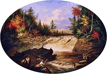
A painting by Cornelius Krieghoff, showing one of the waterfalls along the Shawinigan
|
|
| Other name(s) | Petite rivière Shawinigan, Shawinigan River, Little Shawinigan River |
| Country | Canada |
| Region | Saint-Mathieu-du-Parc, Shawinigan, Mauricie |
| Physical characteristics | |
| Main source | Areas in and near La Mauricie National Park |
| River mouth | Confluence with the Saint-Maurice in the baie de Shawinigan 46°32′18″N 72°46′08″W / 46.53833°N 72.76889°W |
| Basin features | |
| Progression | Shawinigan—Saint-Maurice—Saint Lawrence—Atlantic Ocean |
The Shawinigan River is a cool river in Quebec, Canada. It starts north of the city of Shawinigan and then flows right through it! This river is a branch of the bigger Saint-Maurice River, joining it on its right side.
Contents
Where the Shawinigan River Flows
The Shawinigan River begins in beautiful natural areas. It flows through forests, farms, and even parts of the city of Shawinigan. At its very start, it collects water from lakes like Lac Barnard and Wapizagonke Lake. These lakes are found near the southern part of La Mauricie National Park.
The River's Journey
As the river travels, its waters first head south. You can even see the "chutes du diable" (which means "devil's falls") along the way! After that, the river turns east, winding and twisting like a snake.
It then passes through the Saint-Gérard area of Shawinigan, where it turns south again. The river continues flowing southwest, running alongside Quebec Autoroute 55. Here, the water drops, creating more waterfalls! There's even a special spot nearby where you can stop and watch the amazing view.
Finally, the Shawinigan River flows into a bay called "baie de Shawinigan." This is where it meets the mighty Saint-Maurice River, right near the big Shawinigan hydroelectric complex.
Bridges Over the River
Many bridges cross the Shawinigan River, helping people get around. Some of the main bridges include:
- Route 153 (Boulevard Pie-XII Coast and Bay)
- Route 351 (Trudel street)
- Quebec Autoroute 55
- Rue Bellevue, in Shawinigan
- Rue de la Montagne
- Chemin Principal
- Chemin Saint-François (which has three different bridges!)
What's in a Name?
The name "Rivière Shawinigan" was officially recorded on December 5, 1968. This was done by the Geographical Names Board of Canada, which keeps track of all the names of places in Canada.
 | Valerie Thomas |
 | Frederick McKinley Jones |
 | George Edward Alcorn Jr. |
 | Thomas Mensah |


