Sherman Island (Antarctica) facts for kids
|
Location in Antarctica
|
|
| Geography | |
|---|---|
| Location | Antarctica |
| Coordinates | 72°40′S 99°45′W / 72.667°S 99.750°W |
| Area | 1,121 km2 (433 sq mi) |
| Length | 51 km (31.7 mi) |
| Width | 19 km (11.8 mi) |
| Administration | |
| Administered under the Antarctic Treaty System | |
| Demographics | |
| Population | Uninhabited |
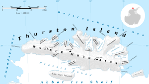
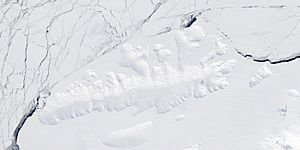
Sherman Island is an island in Antarctica. It is covered in ice all year round. The island is about 51 kilometers (32 miles) long and 16 kilometers (10 miles) wide.
Sherman Island is located south of Thurston Island. It sits in the middle of a body of water called Peacock Sound. The island rises above the Abbot Ice Shelf, which is a large floating sheet of ice that fills the sound.
How Sherman Island Was Discovered
Sherman Island was first mapped using pictures taken from airplanes. These aerial photographs were captured by the US Navy during an operation called Operation Highjump. This happened in December 1946.
Who Is Sherman Island Named After?
The island was named by the US-ACAN, which stands for the United States Advisory Committee on Antarctic Names. They named it after Admiral Forrest Sherman. He was a very important person in the US Navy.
Admiral Sherman was the Chief of Naval Operations from 1949 to 1951. During his time, he helped prepare the US Navy to support the upcoming International Geophysical Year (IGY) operations. The IGY was a big scientific effort where many countries worked together to study Earth.
See also
 In Spanish: Isla Sherman para niños
 | Laphonza Butler |
 | Daisy Bates |
 | Elizabeth Piper Ensley |


