
Shikarpur District facts for kids
Quick facts for kids
Shikarpur District
ضلعو شڪارپور
|
|
|---|---|
 |
|
| Country | Pakistan |
| Province | Sindh |
| Headquarters | Shikarpur |
| Area | |
| • Total | 2,640 km2 (1,020 sq mi) |
| Population
(2017)
|
|
| • Total | 1,231,481 |
| • Density | 466.5/km2 (1,208.2/sq mi) |
| Time zone | UTC+5 (PST) |
| Website | Shikarpur Sindh www.shikarpur.tk |
Shikarpur District is a region in Pakistan. It is located in the Sindh province. The main city of the district is Shikarpur.
The district is divided into four smaller areas. These areas are called Talukas. They are Lakhi Ghulam Shah, Garhi Yasin, Khanpur, and Shikarpur itself. The district covers about 2,512 square kilometers.
In 2017, over 1.2 million people lived in Shikarpur District. Most of the people speak the Sindhi language.
Contents
A Look at History
In 1843, the East India Company took control of Sindh. They created three main administrative areas. These were Hyderabad, Karachi, and Shikarpur.
Shikarpur city was the main headquarters for the district until 1901. After that, the British government moved the headquarters to Sukkur. Back then, Shikarpur District was much larger. It included 14 Talukas and covered almost all of North Sindh. This was except for the area known today as Khairpur.
How Shikarpur District is Divided
Shikarpur District is split into four smaller administrative parts. These parts are called tehsils. Each tehsil helps manage the local area.
The Tehsils of Shikarpur
- Garhi Yaseen Tehsil
- Khan Pur Tehsil
- Lakhi Tehsil
- Shikarpur Tehsil
Images for kids
-
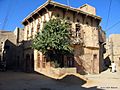
An old building in Shikarpur shows its unique architecture.

