Shire of Derby–West Kimberley facts for kids
Quick facts for kids Shire of Derby/West KimberleyWestern Australia |
|||||||||||||||
|---|---|---|---|---|---|---|---|---|---|---|---|---|---|---|---|

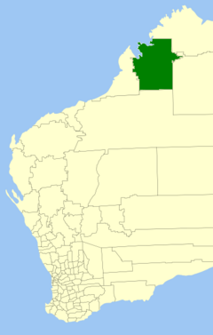
Location in Western Australia
|
|||||||||||||||
| Established | 1884 | ||||||||||||||
| Area | 104,080 km2 (40,185.5 sq mi) | ||||||||||||||
| President | Peter McCumstie | ||||||||||||||
| Council seat | Derby | ||||||||||||||
| Region | Kimberley | ||||||||||||||
| State electorate(s) | Kimberley | ||||||||||||||
| Federal Division(s) | Durack | ||||||||||||||
 |
|||||||||||||||
| Website | Shire of Derby/West Kimberley | ||||||||||||||
|
|||||||||||||||
The Shire of Derby–West Kimberley is a large area in northern Western Australia. It is one of four local government areas in the Kimberley region. This shire covers a huge space, about 104,080 square kilometres (40,185 square miles). Most of this land is not heavily populated.
In 2016, nearly 8,000 people lived in the Shire. Most of them live in the main towns. These towns are Derby and Fitzroy Crossing. Derby is also where the Shire's government office is located. There are also about 70 Aboriginal communities spread across the Shire. The main jobs in the Shire include raising sheep and cattle for export. Fishing and tourism are also very important industries here.
Contents
What is the History of the Shire?
The Shire of Derby–West Kimberley has a long history. It started as the West Kimberley Road District on February 10, 1887. Over the years, some areas like Broome separated and then rejoined. Eventually, the Broome area became its own Shire again in 1918.
How Did It Become a Shire?
The area was officially named the Shire of West Kimberley on July 1, 1961. This happened after a new law, the Local Government Act 1960, changed all road districts into shires. Later, on June 11, 1983, its name was changed to the Shire of Derby–West Kimberley.
Early Cattle Stations in the Area
This area is home to many large cattle stations. These are huge farms where cattle are raised. One of the first stations was Yeeda Station. It was started in 1880 by a group called the Murray Squatting Company.
Another important station, Fossil Downs Station, began in 1883. It was started by Dan MacDonald. Cattle arrived in 1886 to stock the land. Other large cattle stations in the Shire include Mount Barnett Station, Cherrabun, Charnley River Station, Glenroy, Gogo, Kimberley Downs, Liveringa, Meda, Mornington, Mount Hart, Mount House, Myroodah, and Noonkanbah Station. All these stations help supply beef to markets.
Parts of the Shire are also important for their heritage. They are included in the West Kimberley heritage assessment area.
Who Represents the Shire?
The Shire of Derby–West Kimberley is governed by an elected council. All nine councillors represent the entire Shire. They work together to make decisions for the community. The current President of the Shire is Peter McCumstie. The Deputy President is Geoff Haerewa.
| Ward | Councillor | Position | ||
|---|---|---|---|---|
| Unsubdivided | Peter McCumstie | President | ||
| Geoff Haerewa | Deputy president | |||
| Andrew Twaddle | ||||
| Paul Bickerton | ||||
| Geoff Davis | ||||
| Brett Angwin | ||||
| Brian Ellison | ||||
| Kerrissa O’Meara | ||||
| Wayne Foley | ||||
Towns and Communities
The Shire of Derby–West Kimberley has several towns and localities. Here is a list of some of them, along with their population and size from the most recent census:
| Locality | Population | Area | Map |
|---|---|---|---|
| Camballin | 500 (2021) | [convert: needs a number] | |
| Derby | 3,222 (2021) | [convert: needs a number] | |
| Durack * | 169 (2021) | [convert: needs a number] | |
| Fitzroy Crossing | 1,181 (2021) | [convert: needs a number] | |
| Geegully Creek | 9 (2021) | [convert: needs a number] | |
| Gibb * | 80 (2021) | [convert: needs a number] | |
| Jarlmadangah Burru Community | 35 (2021) | [convert: needs a number] | |
| Kimbolton | 52 (2021) | [convert: needs a number] | |
| King Leopold Ranges | 265 (2021) | [convert: needs a number] | |
| Meda | 17 (2021) | [convert: needs a number] | |
| Mount Hardman | 502 (2021) | [convert: needs a number] | |
| Mueller Ranges * | 366 (2021) | [convert: needs a number] | |
| Roebuck * | 606 (2021) | [convert: needs a number] | |
| St George Ranges | 1,133 (2021) | [convert: needs a number] | |
| Waterbank * | 110 (2021) | [convert: needs a number] | |
| Willare | 127 (2021) | [convert: needs a number] |
- (* means the locality is only partly inside this Shire)
Indigenous Communities in the Shire
The Shire of Derby–West Kimberley is home to several Indigenous communities. These include:
Heritage Places
There are many places in the Shire of Derby–West Kimberley that are important for their history and heritage. As of 2023, 100 places are listed as heritage sites. Twenty of these are on the State Register of Heritage Places. This means they are officially recognized as very important historical sites.
 | George Robert Carruthers |
 | Patricia Bath |
 | Jan Ernst Matzeliger |
 | Alexander Miles |

