Shotwell, North Carolina facts for kids
Quick facts for kids
Shotwell, North Carolina
|
|
|---|---|

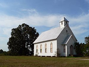
Historic Oaky Grove Methodist Church in Shotwell, North Carolina
|
|
| Country | United States |
| State | North Carolina |
| County | Wake |
| Elevation | 289 ft (88 m) |
| Time zone | UTC-5 (Eastern (EST)) |
| • Summer (DST) | UTC-4 (EDT) |
| Area code(s) | 919 |
| FIPS code | 61740 |
| GNIS feature ID | 1006371 |
Shotwell is a small, rural area in eastern Wake County, North Carolina, United States. It is not a city or town with its own government. Instead, it is an unincorporated community. This means it is a collection of homes and businesses that are part of the larger county.
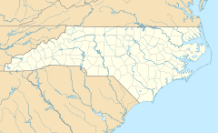
Shotwell is located about 4 miles (6.4 km) south of Knightdale. It is also about 11 miles (18 km) east of Raleigh, a much larger city. Several roads meet here, including Smithfield, Mial Plantation, Major Slade, Grasshopper, and Turnipseed Roads.
Discovering Shotwell, North Carolina
Shotwell is a quiet place with a long history. People have lived in this area since the early 1800s. Over the years, many interesting buildings have been built here. These old structures tell stories about the past.
A Glimpse into Shotwell's History
In the late 1800s, Shotwell was a bit more active. A post office was opened in 1883. This was a big deal for the community. It made sending and receiving mail much easier. However, the post office did not stay open for very long. It closed less than 20 years later.
One of the most important historical places in Shotwell is Oaky Grove. This site was recognized for its history in 1993. It was added to the National Register of Historic Places. This list includes places across the country that are important to American history. Being on this list helps protect the site for future generations.
 | Delilah Pierce |
 | Gordon Parks |
 | Augusta Savage |
 | Charles Ethan Porter |


