Shrum, Missouri facts for kids
Quick facts for kids
Shrum, Missouri
|
|
|---|---|

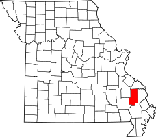
Location of Bollinger County, Missouri
|
|
| Country | United States |
| State | Missouri |
| County | Bollinger |
| Township | Crooked Creek |
| Elevation | 587 ft (179 m) |
| Time zone | UTC-6 (Central (CST)) |
| • Summer (DST) | UTC-5 (CDT) |
| Area code(s) | 573 |
| GNIS feature ID | 752143 |
Shrum is a small, unincorporated community located in Bollinger County, Missouri, in the United States. An "unincorporated community" means it's a group of homes and businesses that isn't officially a town or city with its own local government. People live there, but it's managed by the county.
Contents
What is Shrum, Missouri?
Shrum is a quiet community in the southeastern part of Crooked Creek Township. It's a place where people live without a formal town council or mayor. Instead, the county government handles services like roads and public safety for the area.
Where is Shrum Located?
This community is found in the state of Missouri, which is in the central part of the United States. Shrum is specifically located in Bollinger County. If you were to look on a map, you would find it about 5.5 miles (or 8.8 kilometers) east of another community called Bessville.
How Shrum Got Its Name
Shrum was established in the year 1900. The community was named after a person who owned land in the area, a man named Nicholas Shrum. It was common for new settlements to be named after important local figures or landowners at that time.
The Shrum Post Office
For many years, Shrum had its own post office. This post office helped local residents send and receive mail. It was open and serving the community from 1898 until 1937. After 1937, mail services for Shrum likely became part of a nearby larger post office.
 | Charles R. Drew |
 | Benjamin Banneker |
 | Jane C. Wright |
 | Roger Arliner Young |

