Sierra de Gádor facts for kids
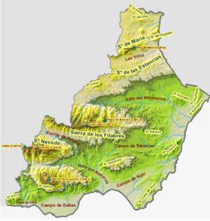
The Sierra de Gádor (also called Sierra Gador) is a mountain range in the southwest part of the Almería province in Spain.
It sits between the Sierra Nevada mountains to the north and the Mediterranean Sea to the south. This makes it a special place with both high peaks and views of the sea.
Contents
Exploring the Mountains
The Sierra de Gádor is a mountain area that stands alone. It is in a very dry or "arid" region. The land here is very bumpy and uneven, with many high points and deep valleys.
Highest Peaks and Their Heights
The tallest mountains in Sierra de Gádor are:
- Morrón de la Lagunilla, which is 2,247 meters (about 7,372 feet) high.
- Pico Colorado, standing at 2,215 meters (about 7,267 feet).
- Nuevo Mundo, also 2,215 meters (about 7,267 feet) tall.
- Pico de las Cabras, reaching 2,000 meters (about 6,562 feet).
- Dos Hermanas, at 1,996 meters (about 6,549 feet).
- El Pecho Cuchillo, which is 1,955 meters (about 6,414 feet) high.
As you move towards the east, the mountains become a bit lower. Some of these eastern peaks include Molinero (1,499 meters), Piorno (1,444 meters), and Pozuelo (1,263 meters).
The Eastern Side: Sierra de Enix
The eastern part of this mountain range is also known as Sierra de Enix. It gets its name from the town of Enix, which is the main town in this area.
This eastern part has two different types of land:
- A valley area made of soft, layered rock materials.
- A hilly area with mountains up to 1,000 meters (about 3,280 feet) high. These hills are mostly covered with bushes and grasses.
See also
- In Spanish: Sierra de Gádor para niños
 | Chris Smalls |
 | Fred Hampton |
 | Ralph Abernathy |


