Sigoyer, Hautes-Alpes facts for kids
Quick facts for kids
Sigoyer
|
||
|---|---|---|

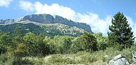
A view of the south side of the Corniche de Céûse, seen from Sigoyer
|
||
|
||
| Country | France | |
| Region | Provence-Alpes-Côte d'Azur | |
| Department | Hautes-Alpes | |
| Arrondissement | Gap | |
| Canton | Tallard | |
| Area
1
|
24.38 km2 (9.41 sq mi) | |
| Population
(Jan. 2021)
|
Lua error in Module:Wd at line 1,575: attempt to index field 'wikibase' (a nil value). | |
| Time zone | UTC+01:00 (CET) | |
| • Summer (DST) | UTC+02:00 (CEST) | |
| INSEE/Postal code |
05168 /05130
|
|
| Elevation | 639–2,000 m (2,096–6,562 ft) (avg. 1,060 m or 3,480 ft) |
|
| 1 French Land Register data, which excludes lakes, ponds, glaciers > 1 km2 (0.386 sq mi or 247 acres) and river estuaries. | ||
Sigoyer is a small town, also called a commune, located in the Hautes-Alpes department in southeastern France. It is a beautiful area known for its natural landscapes.
Contents
About Sigoyer
Sigoyer is nestled in the French Alps, offering stunning views and a peaceful environment. A "commune" is like a local government area, similar to a township or a small municipality. The "department" is a larger administrative region, much like a county in other countries.
Who Leads Sigoyer?
The leader of Sigoyer is called the mayor. The current mayor is Maurice Ricard. Mayors are elected by the people living in the commune. They help manage local services and make decisions for the community.
How Many People Live Here?
The number of people living in Sigoyer has changed over the years. In 1962, about 304 people lived there. The population stayed around that number for a while.
By 1975, it dropped slightly to 245 residents. However, since then, Sigoyer has seen its population grow steadily. In 1999, there were 583 people. By 2008, the population reached 650. This shows that more people are choosing to live in this charming commune.
Getting Around Sigoyer
Roads are the main way to travel in and out of Sigoyer.
Main Roads
Two important roads, the D19 and D219, pass through the commune. These roads connect Sigoyer to nearby towns and villages. They are essential for residents and visitors to get around the area.
Want to Learn More?
- In Spanish: Sigoyer (Altos Alpes) para niños


