Slades Corners, Wisconsin facts for kids
Quick facts for kids
Slades Corners, Wisconsin
|
|
|---|---|

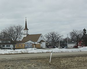
Downtown Slades Corners from Wisconsin Highway 50
|
|
| Country | United States |
| State | Wisconsin |
| County | Kenosha |
| Town | Wheatland |
| Elevation | 866 ft (264 m) |
| Time zone | UTC-6 (Central (CST)) |
| • Summer (DST) | UTC-5 (CDT) |
| Area code(s) | 262 |
| GNIS feature ID | 1574263 |
Slades Corners is a small, quiet community in Wisconsin. It's a place where people live in homes and work on farms. You can find it in the western part of Kenosha County, within the town of Wheatland.
Slades Corners got its name from an early settler named Tom Slade. He moved to this area around 1840. That was eight years before Wisconsin officially became a state! Tom Slade settled on a large piece of land, about 640 acres, which is like 480 football fields.
Contents
Exploring Slades Corners: A Small Wisconsin Community
Slades Corners is known as an "unincorporated community." This means it's a group of homes and businesses that don't have their own local government like a city or village. Instead, it's part of the larger town of Wheatland.
Where is Slades Corners Located?
This community is found at the intersection of Old Highway 50 and 400th Avenue. 400th Avenue is also known as Kenosha County Highway P or Dyer Lake Road. It's a peaceful spot, surrounded by the natural beauty of Wisconsin.
The History of Slades Corners
The story of Slades Corners began with Tom Slade. He was one of the first people to build a home and start a farm here. His arrival in 1840 helped shape the area into the community it is today. Early settlers like Tom Slade played a big role in developing Wisconsin.
Life in an Agricultural Community
Because Slades Corners is an "agricultural community," farming is an important part of its identity. Farms in the area grow crops and raise animals. This helps provide food for people living nearby and beyond. It's a reminder of Wisconsin's strong farming roots.
 | Misty Copeland |
 | Raven Wilkinson |
 | Debra Austin |
 | Aesha Ash |


