Slavníč facts for kids
Quick facts for kids
Slavníč
|
|
|---|---|
|
Municipality
|
|

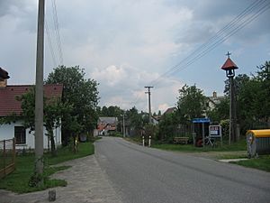
Centre of Slavníč
|
|
| Country | |
| Region | Vysočina |
| District | Havlíčkův Brod |
| First mentioned | 1226 |
| Area | |
| • Total | 2.14 km2 (0.83 sq mi) |
| Elevation | 544 m (1,785 ft) |
| Population
(2024-01-01)
|
|
| • Total | 71 |
| • Density | 33.18/km2 (85.9/sq mi) |
| Time zone | UTC+1 (CET) |
| • Summer (DST) | UTC+2 (CEST) |
| Postal code |
582 55
|
Slavníč is a small village and municipality in the Czech Republic. It is located in the Havlíčkův Brod District within the Vysočina Region. This quiet place is home to about 70 people.
Contents
What is Slavníč Like?
Slavníč is a municipality, which is like a small local government area. It includes the main village of Slavníč. The village was first mentioned way back in 1226, making it quite old!
Where is Slavníč Located?
Slavníč is found in the Vysočina Region of the Czech Republic. This region is known for its beautiful highlands. The village is part of the Havlíčkův Brod District.
How Many People Live in Slavníč?
The population of Slavníč is very small. As of 2024, only about 71 people live there. This makes it a very peaceful and close-knit community.
How Has the Population Changed Over Time?
Looking at history, Slavníč used to have more people. In 1869, there were 269 residents. The number slowly went down over many years. By 2001, it reached its lowest with just 40 people. Recently, the population has started to grow a little again.
- 1869: 269 people
- 1900: 250 people
- 1950: 158 people
- 1980: 62 people
- 2001: 40 people
- 2021: 67 people
Getting Around Slavníč
Even though Slavníč is a small village, an important road passes through it. The D1 motorway connects two major cities: Prague and Brno. This highway helps people travel across the country.
See also
 In Spanish: Slavníč para niños


