Snake River (Massachusetts) facts for kids
Quick facts for kids Snake River |
|
|---|---|

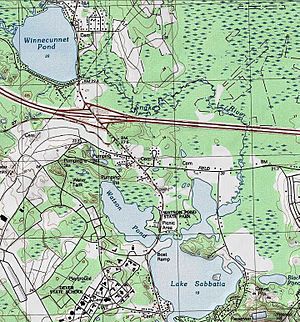
USGS map of the Snake River and surrounding areas
|
|
| Country | United States |
| State | Massachusetts |
| Physical characteristics | |
| Main source | Winnecunnet Pond 41°58′02″N 71°07′35″W / 41.9671°N 71.1265°W |
| River mouth | Lake Sabbatia Taunton 41°56′51″N 71°06′38″W / 41.9475°N 71.1106°W |
| Length | 4 mi (6.4 km) |
The Snake River is a small river located in Bristol County, Massachusetts. It flows for about 4 miles (6.4 kilometers). This river starts at Winnecunnet Pond and ends in Lake Sabbatia. Both of these places are in the northern part of Taunton, Massachusetts.
Contents
What is the Snake River?
The Snake River is a short but important waterway. It helps connect different bodies of water. Even though it's small, it plays a role in the local environment. Rivers like the Snake River are vital for nature. They provide homes for animals and plants.
Where Does the River Flow?
The journey of the Snake River begins at Winnecunnet Pond. This pond is its starting point, also known as its source. From there, the river travels through the landscape. It makes its way towards its final destination.
The river's path ends when it flows into Lake Sabbatia. This lake is located in Taunton. Lake Sabbatia is a larger body of water. The Snake River adds its flow to the lake's waters.
Part of a Bigger Water System
The Snake River is not alone. It is part of a much larger network of waterways. This network is called a watershed. A watershed is an area of land. All the water in that area drains into a common river, lake, or ocean.
The Snake River belongs to the Mill River watershed. The Mill River then flows into the Taunton River. Finally, the Taunton River empties into Narragansett Bay. This means water from the Snake River eventually reaches the ocean.
Protecting the Environment
The Snake River is also part of a special area. This area is called the Canoe River Aquifer Area of Critical Environmental Concern (Massachusetts) (ACEC). An ACEC is a place that needs extra protection. It is important for its natural resources.
The Canoe River Aquifer is a source of underground water. This water is very important for people and wildlife. Protecting the Snake River helps keep this water clean. It also helps protect the plants and animals that live there.
 | Emma Amos |
 | Edward Mitchell Bannister |
 | Larry D. Alexander |
 | Ernie Barnes |

