
Sofala Province facts for kids
Quick facts for kids
Sofala
|
|
|---|---|
.jpg)
Gogogo, the highest peak of the Gorongosa mountain complex
|
|

Sofala, Province of Mozambique
|
|
| Country | Mozambique |
| Capital | Beira |
| Area | |
| • Total | 68,018 km2 (26,262 sq mi) |
| Population
(2017 census)
|
|
| • Total | 2,259,248 |
| • Density | 33.21544/km2 (86.0276/sq mi) |
| Postal code |
21xx
|
| Area code(s) | (+258) 23 |
Sofala is a province located in the country of Mozambique. It is an important region with a rich history and beautiful natural areas. The capital city of Sofala province is Beira.
Contents
Exploring Sofala Province
Sofala is a large province in Mozambique. It covers an area of about 68,018 square kilometers. In 2017, over 2.2 million people lived here. The province is known for its diverse landscapes and important rivers.
Rivers and Waterways
Several rivers flow through Sofala province. These rivers are vital for the local communities and the environment. Some of the main rivers include the Chiveve River, the Buzi River, and the Save River. These waterways help shape the land and support wildlife.
Gorongosa National Park
One of the most famous places in Sofala is Gorongosa National Park. This huge park is located at the southern end of the Great African Rift Valley. It covers thousands of square kilometers. The park is home to many different animals and plants.
Inside Gorongosa National Park, you will find Mount Gorongosa. This mountain is 1,863 meters (6,112 feet) tall. It is considered a sacred place by the people of Mozambique. The park is a major effort to protect nature and help local communities.
How Sofala is Organized
Sofala Province is divided into smaller areas called districts. These districts help manage the different parts of the province. There are 12 districts in Sofala.
Districts of Sofala
The 12 districts that make up Sofala Province are:
- Buzi District
- Caia District
- Chemba District
- Cheringoma District
- Chibabava District
- Dondo District
- Gorongosa District
- Marromeu District
- Machanga District
- Maringué District
- Muanza District
- Nhamatanda District
Images for kids
-
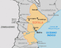
Provincial map
-
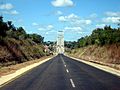
EN1 road crossing Save river, Inhambane/Sofala, Mozambique
-
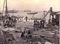
Port of Beira in 1902


See also
 In Spanish: Provincia de Sofala para niños
