
South Denmark Road Covered Bridge facts for kids
Quick facts for kids South Denmark Road Bridge |
|
|---|---|
_Covered_Bridge_1.jpg) |
|
| Coordinates | 41°43′03″N 80°41′25″W / 41.71750°N 80.69028°W |
| Locale | Ashtabula County, Ohio, United States |
| Characteristics | |
| Design | single span, Town truss |
| Total length | 100 feet (30.5 m) |
| History | |
| Construction begin | 1895 |

|
|

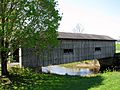
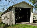
The South Denmark Road Bridge is a special kind of bridge called a covered bridge. It crosses over Mill Creek in a place called Denmark Township, which is in Ashtabula County, Ohio, United States. This bridge is one of 16 covered bridges you can still drive across in Ashtabula County.
It was built using a design called a Town truss, which is a way of arranging wooden beams to make the bridge strong. Even though a new road was built around it in 1975, the South Denmark Road Bridge is still open for cars, but only for light traffic.
What is a Covered Bridge?
A covered bridge is a wooden bridge that has walls and a roof, just like a house. The main reason bridges were covered was to protect the wooden parts from rain, snow, and sun. This helped the bridges last much longer. Without a cover, the wood would rot and wear out quickly.
History of the Bridge
This bridge has been around for a long time!
- 1895 – The South Denmark Road Bridge was built.
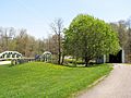
- 1975 – A new road was built that went around the bridge. This is called "bypassing" the bridge. Even though it was bypassed, the old bridge was kept and is still used today for light traffic.
How Big is the Bridge?
Here are some interesting facts about the size of the South Denmark Road Bridge:
- Span: The main part of the bridge that goes over the creek is 76 feet (23 m) long.
- Total Length: From one end to the other, the bridge is 100 feet (30 m) long.
- Width: It is 13 feet 3 inches (4.04 m) wide, which is enough for one car at a time.
- Height: The bridge is about 11 feet (3.4 m) tall.
Images for kids
-
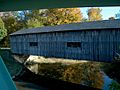
View from the north
-
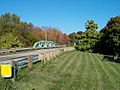
Steel span on relocated road
-
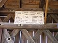
Build placard
-
-
-
_Covered_Bridge_2.jpg)
_Steel_Bridge.jpg)


