South Jefferson, Roanoke, Virginia facts for kids
Quick facts for kids
South Jefferson
|
|
|---|---|

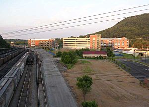
Carilion Clinic campus and the Norfolk Southern Railway
|
|
| Country | United States |
| State | Virginia |
| City | Roanoke |
| Elevation | 922 ft (281 m) |
| Time zone | UTC-5 (EST) |
| • Summer (DST) | UTC-4 (EDT) |
| ZIP Codes |
24016
|
| Area code(s) | 540 |
South Jefferson is a neighborhood in Roanoke, Virginia. It is located in the southeastern part of the city. The Roanoke River forms its southern and eastern borders. The Roy L. Webber Expressway is to its west. South Jefferson Street runs through the middle of the neighborhood. It is next to Old Southwest on the west. It also borders Belmont and Downtown to the north. To the east, it connects to Riverland/Walnut Hills by the Walnut Street Bridge.
History and Development
For a long time, South Jefferson was a place where many different factories and businesses operated. In May 2000, the City of Roanoke decided to make it a special project. They called it the South Jefferson Redevelopment Area. This meant they wanted to improve and rebuild parts of the neighborhood.
Since then, the area has seen many new buildings and changes. Important projects include the Carilion Clinic campus. This is a large medical center. Also, the Virginia Tech Carilion School of Medicine was built here. These new developments have brought new life and activity to South Jefferson.
 | Sharif Bey |
 | Hale Woodruff |
 | Richmond Barthé |
 | Purvis Young |

