Spree-Neiße facts for kids
Quick facts for kids
Spree-Neiße
|
|
|---|---|
 |
|
| Country | |
| State | Brandenburg |
| Capital | Forst |
| Area | |
| • Total | 1,647.8 km2 (636.2 sq mi) |
| Population
(2002)
|
|
| • Total | 144,161 |
| • Density | 87.4870/km2 (226.590/sq mi) |
| Time zone | UTC+1 (CET) |
| • Summer (DST) | UTC+2 (CEST) |
| Vehicle registration | SPN |
| Website | landkreis-spree-neisse.de |
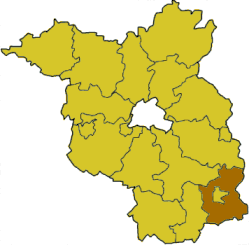
Spree-Neiße is a special area in Germany called a 'district' (or Kreis). It's located in the southern part of Brandenburg, which is a state in Germany.
The city of Cottbus is completely surrounded by this district. Also, to the east of Spree-Neiße, you'll find the country of Poland.
This district was created in 1993. It was formed by joining four older districts: Cottbus-Land, Forst, Guben, and Spremberg.
Contents
What is Spree-Neiße?
Spree-Neiße is a district in Germany. A district is like a county or a region. It has its own local government. This government helps manage things like schools, roads, and public services for the people living there.
The district gets its name from two rivers. The Spree River flows through the area. The Neiße River forms part of its eastern border with Poland.
The Story of the Spree-Neiße Coat of Arms
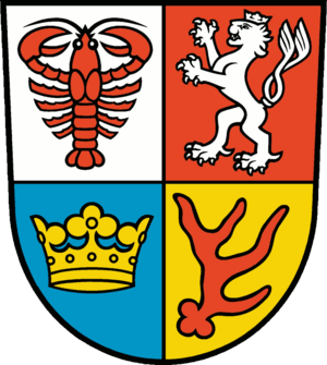
The coat of arms for Spree-Neiße is a special symbol. It tells the story of the district's past. It has four different parts, one for each of the old districts that joined together.
- Crayfish: In the top-left part, you'll see a crayfish. This animal represents the old district of Cottbus-Land. You can also find a crayfish on the coat of arms of the city of Cottbus.
- Lion: The top-right part shows a lion. This lion is a symbol of the Kingdom of Bohemia. The old district of Spremberg used to be part of the lands ruled by the Bohemian kings.
- Deer Antler: In the bottom-right section, there's a deer antler. This symbol comes from the old district of Forst. It was taken from the coat of arms of the Lords of Biberstein, who were important rulers there long ago.
- Crown: The bottom-left part has a crown. This crown also represents the kings of Bohemia. It symbolizes the old district of Guben, which was also connected to the Bohemian kingdom.
Towns and Communities in Spree-Neiße
The Spree-Neiße district is home to many towns and smaller communities. These places are organized in different ways. Some towns manage themselves, while others work together in groups called Ämter. An Amt is like a group of smaller towns and villages that share some services.
Self-Governing Towns
These towns manage their own affairs without being part of an Amt:
- Drebkau
- Forst
- Guben
- Spremberg
- Welzow
Self-Governing Communities
These are smaller communities that also manage themselves:
- Kolkwitz
- Neuhausen/Spree
- Schenkendöbern
Communities in Ämter
Here are the Ämter and the communities that belong to them:
Burg (Spreewald) Amt
The main town for this Amt is Burg.
- Briesen
- Burg
- Dissen-Striesow
- Guhrow
- Schmogrow-Fehrow
- Werben
Döbern-Land Amt
The main town for this Amt is Döbern.
- Döbern
- Felixsee
- Groß Schacksdorf-Simmersdorf
- Hornow-Wadelsdorf
- Jämlitz-Klein Düben
- Neiße-Malxetal
- Tschernitz
- Wiesengrund
Peitz Amt
The main town for this Amt is Peitz.
- Drachhausen
- Drehnow
- Heinersbrück
- Jänschwalde
- Peitz
- Tauer
- Teichland
- Turnow-Preilack
See also

- In Spanish: Distrito de Spree-Neiße para niños
 | Janet Taylor Pickett |
 | Synthia Saint James |
 | Howardena Pindell |
 | Faith Ringgold |


