St. Lewis, Newfoundland and Labrador facts for kids
Quick facts for kids
St. Lewis
Ilha de Frey Luis
Fox Harbour
|
|
|---|---|
|
Town
|
|
| Country | Canada |
| Province | Newfoundland and Labrador |
| Government | |
| • Type | Town Council |
| Area | |
| • Total | 9.25 km2 (3.57 sq mi) |
| Population
(2021)
|
|
| • Total | 181 |
| Time zone | UTC−03:30 (NST) |
| • Summer (DST) | UTC−02:30 (NDT) |
| Postal Code |
A0K 4W0
|
| Area code(s) | 709 |
| Highways | |
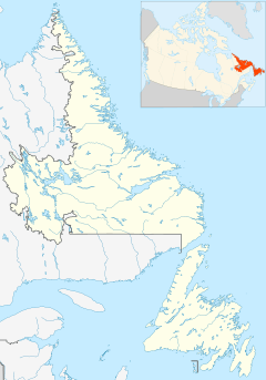
St. Lewis is a small community located on the coast of Labrador. Labrador is part of the province of Newfoundland and Labrador, Canada. It used to be called Fox Harbour. St. Lewis is special because it is the community furthest east on the main part of North America.
This community has a long and interesting history. Europeans first wrote about it very early in Labrador's history. Europeans started living there in the early 1700s. Its safe harbour, good fishing spots, and seal migration routes made it a great place to live. Both European fishers and local Inuit families, who lived along the southern Labrador coast, wanted to settle there.
Geography: Where St. Lewis Is Located
The town of St. Lewis is tucked inside a safe harbour. This harbour is right at the mouth of St. Lewis Bay. Like most of the eastern coast of Labrador, the area has rocky hills. These hills are shaped by the very cold Labrador Current.
It has a subarctic climate. This means cool summers and long, snowy, icy winters. This tough environment helps a strong boreal ecosystem (forests) grow. You'll find forests of black spruce, white spruce, and balsam fir trees. They grow in valleys and along rivers where they are a bit more protected from the weather. The rocky shore of Labrador looks a lot like an Arctic tundra.
St. Lewis is proud to be the easternmost permanent community on the North American mainland. Its location is perfect for watching icebergs and floating ice. These huge ice formations drift by every summer. Newfoundland and Labrador Tourism calls this area "Iceberg Alley".
History: A Look Back at St. Lewis
St. Lewis is one of the oldest places in Labrador to be named on maps. It appeared on maps as early as 1502-1503. Back then, it was called Ilha de Frey Luis.
The Loder family from Harbour Grace started a fish trading business here. They built buildings in the community. These buildings have now been fixed up. They are used to show exhibits about the history of St. Lewis.
Since 1957, St. Lewis has been a radar site. The United States built the Fox Harbour Air Station here. This was a radar site that was part of the Pinetree Radar System. The Canadian Coast Guard also ran a Loran C station in St. Lewis. This station sent out radio signals for navigation. In 2010, they stopped broadcasting the Loran C signal.
In 2012, the local fish plant in St. Lewis closed down.
Demographics: People of St. Lewis
In the 2021 Census, Statistics Canada counted the population of St. Lewis. There were 181 people living there. They lived in 72 homes out of 93 total private homes. This was a small change from its 2016 population of 194 people. The land area of St. Lewis is about 10.04 square kilometers.
 | Calvin Brent |
 | Walter T. Bailey |
 | Martha Cassell Thompson |
 | Alberta Jeannette Cassell |


