St. Margaret's Bay, Nova Scotia (administrative district) facts for kids
Quick facts for kids
St. Margarets Bay
|
|
|---|---|
|
Administrative District
|
|

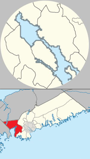
Location of St. Margarets Bay planning area of municipal Halifax.
|
|
| Country | |
| Province | |
| Municipality | Halifax Regional Municipality |
| Founded | 1612 (Head of St. Margarets Bay) |
| Communities | Black Point, Boutiliers Point, French Village, Glen Haven, Glen Margaret, Hackett's Cove, Head of St. Margaret's Bay, Hubbards, Hubley, Indian Harbour, Ingramport, Lewis Lake, Peggys Cove, Queensland, Seabright, Simms Settlement, Tantallon, Upper Tantallon |
| Time zone | UTC−4 (AST) |
| • Summer (DST) | UTC−3 (ADT) |
St. Margarets Bay is a beautiful coastal area located in Nova Scotia, Canada. It's part of the larger Halifax Regional Municipality. This area is known for its stunning ocean views, charming fishing villages, and many outdoor activities. It's a popular spot for both locals and visitors who love nature and the sea.
Contents
What is St. Margarets Bay?
St. Margarets Bay is more than just a bay; it's also an administrative district. This means it's a specific area that helps manage local services and planning. It includes many small communities that stretch along the coastline and inland. The bay itself is a large inlet of the Atlantic Ocean.
Where is St. Margarets Bay located?
You can find St. Margarets Bay on the eastern shore of Nova Scotia. It's southwest of the city of Halifax. The bay opens up to the vast Atlantic Ocean. Its location makes it a perfect place for boating and enjoying the ocean breeze.
How big is the St. Margarets Bay area?
The St. Margarets Bay planning area covers a significant part of the Halifax Regional Municipality. While the exact total area isn't listed here, it's large enough to include many different communities. These communities offer a mix of coastal living and quiet, forested areas.
Communities of St. Margarets Bay
The St. Margarets Bay area is made up of many unique communities. Each one has its own special feel and history. These communities work together under the Western Region Community Council. This council helps make decisions for the area.
What communities are in the area?
Some of the well-known communities include:
- Black Point
- Boutiliers Point
- French Village
- Glen Haven
- Glen Margaret
- Hackett's Cove
- Head of St. Margaret's Bay
- Hubbards
- Hubley
- Indian Harbour
- Ingramport
- Lewis Lake
- Peggys Cove
- Queensland
- Seabright
- Simms Settlement
- Tantallon
- Upper Tantallon
Many of these communities are small fishing villages. Others are more residential areas.
What is the history of settlement?
The area has a long history. One of its communities, Head of St. Margaret's Bay, was founded way back in 1612. This shows that people have lived and worked in this beautiful region for centuries. Early settlers were often involved in fishing and forestry.
Life in St. Margarets Bay
Life in St. Margarets Bay is often connected to the ocean. Many people enjoy activities like sailing, kayaking, and swimming. The area also has beautiful hiking trails and parks. It's a great place for anyone who loves the outdoors.
What is the population like?
According to the 2006 Census, the population of the St. Margarets Bay area was recorded. While the exact number isn't shown here, it's a mix of year-round residents and people who visit for holidays. The communities are generally small and friendly.
What is the local government?
The St. Margarets Bay area is governed by the Western Region Community Council. This council is part of the larger Halifax Regional Municipality. They help make decisions about local services, planning, and community development. This ensures the area runs smoothly for everyone.
Images for kids
 | Jewel Prestage |
 | Ella Baker |
 | Fannie Lou Hamer |


