St. Margarets Bay, Nova Scotia facts for kids
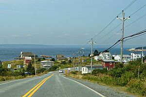
St. Margarets Bay is a beautiful bay located on the Atlantic coast of Nova Scotia, Canada. It sits between Halifax County and Lunenburg County. This area is known for its stunning ocean views and charming coastal communities.
Contents
Exploring St. Margarets Bay
St. Margarets Bay opens directly to the Atlantic Ocean in the south. The eastern side of the bay is formed by the Chebucto Peninsula. The western side is shaped by the Aspotogan Peninsula. The northern part, called the "head of the bay," is part of the main Nova Scotia peninsula.
Beaches and Boating
The shoreline of St. Margarets Bay is mostly rocky. However, you can find several sandy beaches, especially at the northern end. These include Queensland, Black Point, and Cleveland beaches. There is also a sandy beach at Bayswater on the western shore. A small sandy spot can be found on Micou's Island too.
St. Margarets Bay is a popular spot for sailing. Many people enjoy cruising here because the beautiful coast offers safe places to dock boats. There are many natural harbours, coves, and small islands where boats can find shelter.
Communities Around the Bay
Many small towns and villages are located along the shores of St. Margarets Bay. They are divided into three main areas: the Eastern Shore, the Northern Shore, and the Western Shore.
Eastern Shore Towns
These communities are found along the Chebucto Peninsula, moving from south to north:
- Peggys Cove
- Indian Harbour
- Hackett's Cove
- Glen Margaret
- Seabright
- French Village
- Glen Haven
- Tantallon
- Whynacht's Point
- Upper Tantallon
Northern Shore Towns
These communities are located at the very top (head) of the bay, from east to west:
- Allen Heights
- Todd's Island
- Head of St. Margarets Bay
- Mason's Point
- Boutilier's Point
- Ingramport
- Black Point
- Queensland
- Hubbards
Western Shore Towns
These communities are along the Aspotogan Peninsula, moving from north to south:
- Fox Point
- Mill Cove
- Birchy Head
- The Lodge
- Northwest Cove
- Southwest Cove
- Aspotogan
- Bayswater
Islands of the Bay
St. Margarets Bay has many islands, especially near its eastern shore. The Mi'kmaq Nation, the Indigenous people of this area, historically used these islands. Some islands even contain ancient burial sites.
Here are some of the larger islands in the bay:
- Southwest Island
- Horse Island
- Shut-in Island
- Croucher Island
- Owls Head Island (connected to the mainland by a small bridge)
- Moser's Island
- Micou's Island
Swissair Flight 111 Memorial
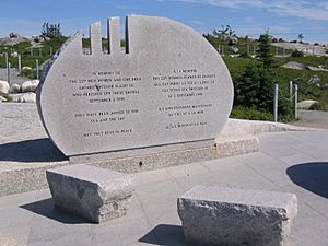
A special memorial for Swissair Flight 111 is located at The Whalesback. This spot is about 1 kilometer northwest of Peggys Cove. This memorial is one of two built to remember the people who died when Swissair Flight 111 crashed into St. Margarets Bay. The accident happened on September 2, 1998.
The crash site is about halfway between The Whalesback Memorial and another memorial. The second memorial is in Bayswater, Nova Scotia, on the western side of the bay.
Meaning of the Memorials
The monument at The Whalesback has a message in English and French. It says: "In memory of the 229 men, women and children aboard Swissair Flight 111 who perished off these shores September 2nd, 1998. They have been joined to the sea, and the sky. May they rest in peace."
The crash site and the two monuments form a triangle. The three marks on the stone at Whalesback represent the numbers 111. If you look along these marks, they point to where the plane crashed. Markings on the other side of the stone point to the Bayswater memorial. The memorial wall at Bayswater lists the names of everyone who was on the flight.
Historical Plans for the Bay
Between World War I and World War II, the US military created different "Colour Coded War Plans." These plans were ideas for how to respond to possible global threats. One plan, called War Plan Red, involved a possible attack against the British Empire. This included a plan for Canada, called War Plan Crimson.
This plan suggested a sea invasion of Halifax and Canada's Maritime provinces. St. Margarets Bay was mentioned as a possible entry point for such an invasion. Luckily, these plans were never put into action.
 | Claudette Colvin |
 | Myrlie Evers-Williams |
 | Alberta Odell Jones |


