St Albans, New Zealand facts for kids
Quick facts for kids
St Albans
|
|
|---|---|
|
Suburb
|
|

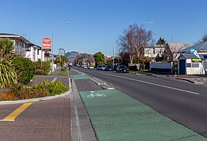
Colombo Street, St Albans, looking south towards the city centre
|
|
| Country | New Zealand |
| Local authority | Christchurch |
| Electoral ward |
|
| Area | |
| • Land | 397 ha (981 acre) |
| Population
(June 2023)
|
|
| • Total | 13,830 |
| Postcode(s) |
8014
|
|
|
||
St Albans is a large suburb located just north of the main city area in Christchurch, New Zealand. It's the second biggest suburb in Christchurch when you look at how many people live there. In 2018, about 13,137 people called St Albans home.
This suburb is part of the Christchurch Central voting area, also known as an electorate. The person who represents this area in the New Zealand Parliament is Duncan Webb. He has been the Member of Parliament since 2017. St Albans is a very varied neighbourhood, with many different types of homes and buildings. You can find everything from older, smaller houses to modern apartments and larger family homes.
Contents
A Look at St Albans' Past
The first people to live in the Christchurch area were the Māori. Back then, the land where St Albans now stands was mostly wetlands (swampy areas) with some patches of grasslands. A very important Māori settlement for gathering food, called Puāri, was located close by, near what is now Victoria Square.
Later, St Albans became a place where many working-class families lived. It was its own separate town, called a borough, from 1881 until 1903. After that, it became part of Christchurch City. The name "St Albans" came from a farm owned by George Dickinson. His farm was named St Albans to remember his cousin, Harriet Mellon, an actress who became the Duchess of St Albans.
Earthquake Impact on St Albans
St Albans was lucky during the 2010 Canterbury earthquake and didn't suffer too much damage. Many chimneys fell, but only a few houses were badly affected. However, the earthquake on 22 February 2011 hit the suburb much harder. Many homes, supermarkets, and shops were seriously damaged, and a lot of them had to be completely torn down.
By 2014, people realised that the earthquakes had also damaged the drainage systems and lowered the ground in some areas. This led to regular flooding in a group of streets known as the Flockton Basin.
Where is St Albans?
The suburb of St Albans has clear borders with other nearby areas:
- To the west, it borders Merivale.
- To the north-west, it is next to Strowan.
- To the north, you'll find Papanui.
- To the north-east, it borders Mairehau.
- To the east, it is next to Edgeware.
- To the south, it borders the Christchurch Central City.
These borders are generally agreed upon, especially by groups like Fire and Emergency NZ.
Debates About the Borders
Sometimes, the exact borders of St Albans are discussed, especially by real estate agents. They might say that more expensive homes in western St Albans are actually in Merivale. The original town of St Albans used to be much larger, including parts of what are now Edgeware, Mairehau, and Merivale. There's even a sign on Bealey Avenue that points to St Albans down Barbadoes Street, but that street is actually in the middle of Edgeware!
In 2013, students studying geography at the University of Canterbury asked people living in St Albans where they thought the borders were. The residents' ideas were different from the official borders used by the Christchurch City Council and New Zealand Post. Residents often thought the northern border was Innes Road, the eastern was Hills Road, the southern was Bealey Avenue, and the western was Papanui Road.
People and Population in St Albans
St Albans covers an area of about 3.97 square kilometres. As of 2023, it has an estimated population of about 13,830 people. This means there are roughly 3,484 people living in each square kilometre.
The population of St Albans has grown over the years:
- In 2006, there were 12,987 people.
- In 2013, the population was 12,768.
- By 2018, it had increased to 13,137.
- In 2023, the population reached 13,830.
At the 2018 New Zealand census, there were 5,448 households in St Albans. There were slightly more females (6,633) than males (6,498). About 15.6% of the people were under 15 years old.
Most people in St Albans (82.9%) are of European or Pākehā background. Other groups include Māori (7.0%), Pasifika (2.0%), and Asian (12.8%). About 28.0% of the people living in St Albans were born overseas.
When it comes to religion, about half of the people (50.6%) said they had no religion. Many others (36.7%) were Christian. Smaller numbers followed other religions like Hindu, Muslim, or Buddhist.
Many adults in St Albans have a good education. About 35.1% of people aged 15 or older had a university degree or higher. Also, 57.6% of people aged 15 or older had a full-time job.
Community Places and Activities
The main centre of St Albans is Edgeware Village, located on Edgeware Road. It has a number of popular shops. The suburb also has three main parks where people can relax and play: St Albans Park, Abberley Park, and Malvern Park.
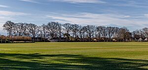
For sports fans, St Albans is home to some important facilities. These include English Park, which is the stadium for the Canterbury United Football Club. It also has Rugby Park, which is the home ground for the Crusaders professional rugby union team.
Learning in St Albans
St Albans has two primary schools for younger students, from Year 1 to Year 6. These are St Albans Primary School and St Albans Catholic School. St Albans School first opened its doors in 1873, and St Albans Catholic School welcomed its first students in 1955.
St Albans News
St Albans is known for its strong community spirit and how well people work together. A great example of this is the local monthly newspaper, the St Albans Neighbourhood News. A group of local residents started this paper in 1993, and it's still being published today as the St Albans News.
The paper is given out to 5,000 homes and businesses and has grown to be 16 pages long. Over the years, it has played a big part in many community issues. These include local planning, discussions about Packe Street Park, and the closure of the Edgeware swimming pool. The newspaper was against the pool's closure. After the community got control of the pool site back, it was announced that the pool would be rebuilt with a kind donation from a local resident.
Well-Known People from St Albans
- Hugh Acland (1874–1956), a famous surgeon.
- John Evans Brown (1827–1895), the first Member of Parliament for St Albans. Browns Road is named after him.
- Richard Hadlee (born 1951), a world-famous cricketer.
- Violet Targuse (1884–1937), a playwright.
- The Wizard of New Zealand (born 1932), who lived in the suburb until his home was destroyed by fire in 2003.
- Tane Norton (1942–2023), a famous All Black rugby player and local business owner.
 | John T. Biggers |
 | Thomas Blackshear |
 | Mark Bradford |
 | Beverly Buchanan |


