
State Road Covered Bridge facts for kids
Quick facts for kids State Road Bridge |
|
|---|---|
_Covered_Bridge_4.jpg) |
|
| Coordinates | 41°53′11″N 80°37′14″W / 41.88639°N 80.62056°W |
| Crosses | Conneaut Creek |
| Locale | Ashtabula County, Ohio, United States |
| Characteristics | |
| Design | single span, Town truss |
| Total length | 157 feet (47.9 m) |
| History | |
| Constructed by | John Smolen Jr. |
| Construction begin | 1983 |

|
|

The State Road Bridge is a cool covered bridge in Monroe Township, Ashtabula County, Ohio. It crosses over Conneaut Creek. This bridge is special because it's one of 17 covered bridges in the county that you can still drive across!
It has a unique design called a Town truss, which is a type of strong wooden framework. The bridge was built using 97,000 feet (30,000 m) of southern pine and oak wood. It also has a 4-foot-tall (1.2 m) window that runs along its entire length.
The State Road Bridge was officially opened in 1983. Its dedication helped start the famous Ashtabula County Covered Bridge Festival. The bridge has a special number, WGCB 35-04-58, which helps identify it. You can find it about 3.9 miles (6.3 km) east-southeast of North Kingsville.
It's important not to confuse the State Road Bridge with another covered bridge in the county. That one is called the Smolen-Gulf Bridge.
Bridge History
The current State Road Bridge was built in 1983. But did you know there was an older bridge here before?
- 1983 – The current bridge was built.
The first covered bridge in this spot was built way back in 1831. Two people named Ira Benton and David Niles built it. It cost them only $100 to build! That original bridge stood strong until 1898.
Bridge Size and Measurements
Here are some interesting facts about how big the State Road Bridge is:
- Span: The main part of the bridge that crosses the creek is 140 feet (42.7 m) long.
- Total Length: The entire bridge measures 157 feet (47.9 m) from one end to the other.
- Width: It is 17 feet 6 inches (5.33 m) wide, which is enough for cars to drive through.
- Height: The bridge stands 14 feet 6 inches (4.42 m) tall.
Gallery
-
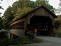
A closer look at the bridge from the south side.
-
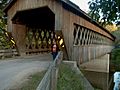
A view of the bridge from the southeast.
-
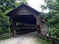
The bridge in July 2014.
-
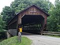
Another view of the bridge from July 2014.
_Covered_Bridge_2.jpg)
_Covered_Bridge_3.jpg)

_-_panoramio.jpg)
