Stockingfield Junction facts for kids
Quick facts for kids Stockingfield Junction |
|
|---|---|

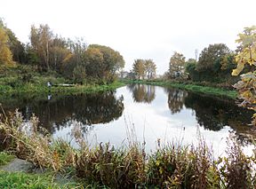
Stockingfield Junction looking towards Port Dundas
|
|
| Specifications | |
| Status | Active |
| Navigation authority | Forth and Clyde Canal |
| History | |
| Date completed | 1777 |
| Date closed | 1963 |
| Date restored | 2002 |
Stockingfield Junction (NS571689) is a special place where two parts of a canal meet. It is located in Lambhill, a part of Glasgow, Scotland. This important junction first opened in 1777. It was closed for a while in 1963 but was later fixed up and reopened in 2001-2002. At first, it was the end of the canal line. Then, from 1777, it became the point where the Port Dundas branch split off from the main Forth and Clyde Canal.
Contents
History of Stockingfield Junction
The canal that came from Edinburgh was built by John Smeaton. It reached Stockingfield in 1775. Because there wasn't enough money, work stopped for two years. This meant Stockingfield Basin and its wharf became the temporary end of the canal. Water filled the canal, and boats started carrying goods on November 10, 1775.
The branch of the canal was finished to Hamiltonhill Basin by November 1777. It reached Port Dundas by 1779. At the same time, the main canal line to Bowling also opened. This is when Stockingfield truly became a junction. The building of the aqueduct (a bridge carrying water) likely covered up where the first canal basin and wharf used to be.
Later maps from the 1800s show a new building called the Lochburn Road House. It stood near Stockingfield House on the canal path. This building was close to a special floating bridge. Canal workers probably used this house to help open and close the bridge for boats. The British Waterways Board tore it down in 1958.
The Floating Bridge at Stockingfield
There used to be a floating bridge at the Stockingfield aqueduct. This bridge made it easy for horses pulling barges to cross from one side of the canal to the other. This helped them move quickly between the main canal path and the paths for the branch lines to Bowling.
Safety Gates for the Canal
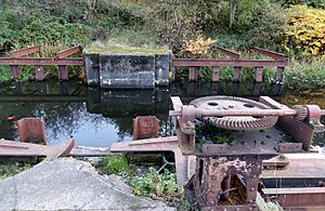
In 1942, during World War II, two very large steel safety gates were built. They were placed on the Edinburgh side of Stockingfield Junction, in an area called the Stockingfield Narrows. These gates were operated by hand cranks. Their main job was to hold back the canal's water. This was a safety measure to stop big floods in Glasgow if bombs destroyed the Stockingfield Aqueduct.
Two more sets of these safety gates were also put in place during the war. One set is at Firhill, called the Firhill Road Narrows, on the Glasgow Branch. Another set was built at the Craighall Road Narrows, near Spiers Wharf. The closest lock on the main Edinburgh line that could control water if there was a break was about 17 miles (27 km) away at Wyndford, Lock 20. The Maryhill Locks (21 to 25) are much closer.
Stockingfield Aqueduct: A Water Bridge
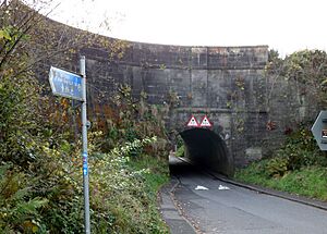
The original Stockingfield Aqueduct (NS57126899) was designed in the 1780s by Robert Whitworth. It was built between 1784 and 1790. This aqueduct still stands today, carrying the main part of the canal over Lochburn Road. It also has a road tunnel arch underneath it.
In the late 1800s, a small ferry operated here. It helped people cross the canal if they wanted to get to the other path leading to Bowling or Port Dundas. As mentioned, a floating bridge also existed here. It made it simple for horses and people to get to the towpath on the other side of the canal junction.
The Bigman Bridge Project
There are plans for a new, exciting bridge at Stockingfield Junction. This project, costing £4.5 million, will be a permanent three-way footbridge. It is designed by the sculptor Andy Scott. The bridge will be suspended from the outstretched arms of a large statue called the 'Big Man'.
Location of Stockingfield Junction
The small area called Stockingfield gave its name to this canal junction. Stockingfield Junction is located four locks and about 20 miles (32.8 km) east of the Union Canal Junction, which is near the famous Falkirk Wheel.
If you travel west from Stockingfield Junction, you will find the Clyde Canal Junction about 9 miles (15.3 km) and twenty locks away. This is where the Forth and Clyde Canal meets the Clyde Estuary at Bowling. To the south, about two locks and 2 miles (4.9 km) away, is the Port Dundas Basin. This basin was also the end point for the Monkland Canal.
The Stockingfield Narrows are the two 'Safety or Stop' gates. They were built in 1942 to help prevent flooding. This was a precaution in case German bombs hit the Stockingfield or Lochburn Aqueduct No 14 during World War II.
 | Chris Smalls |
 | Fred Hampton |
 | Ralph Abernathy |


