Stone Farmhouse facts for kids
Quick facts for kids |
|
|
Stone Farmhouse
|
|
|
U.S. Historic district
Contributing property |
|

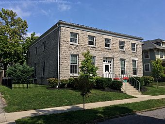
Stone Farmhouse, Buffalo, NY, September 2019
|
|
| Location | 60 Hedley Pl., Buffalo, New York |
|---|---|
| Area | less than one acre |
| Built | 1830 |
| Architectural style | Greek Revival |
| NRHP reference No. | 98001614 |
| Added to NRHP | February 1, 1999 |
The Stone Farmhouse is a very old and important house located in Buffalo, New York, in Erie County, New York. It was built around 1830, making it one of the oldest stone houses still standing in Buffalo. This house shows off a style called Greek Revival architecture, which was popular a long time ago.
The house is a two-story building with a special kind of roof called a hipped roof. It's about 40 feet wide and 50 feet deep. It's a great example of how people built houses in the early 1800s.
Contents
The Stone Farmhouse Story
The Stone Farmhouse has a long history, appearing on maps and in records from many years ago. It helps us understand what Buffalo was like in the past.
Early Days of the Farmhouse
The Stone Farmhouse was built sometime between 1830 and 1850. Maps from the 1850s show that the area where the house stands was once called "Black Rock." This was before Buffalo grew into the big city it is today.
In 1866, a man named Charles G. Curtiss owned the house. Records show he lived there with his wife, Amelia, their four children, his sister, and two helpers. The records even mention that their house was made of "stone," confirming it's the same building.
Life on the Farm
The Stone Farmhouse was once part of a working farm. In 1870, Amelia Curtiss was listed as the head of the household. The farm had 15 acres of land that was used for growing crops and 5 acres of woodland.
The farm grew many different things. They had "Indian corn," peas, beans, and Irish potatoes. They also had an orchard, which means they grew fruit trees. The farm produced a lot of goods for the market, like vegetables and butter. They even had horses and a cow. This shows that the Stone Farmhouse was an active part of the community, providing food and goods.
Changes Around the House
Over the years, the area around the Stone Farmhouse changed a lot. New streets were built, and other buildings appeared. For example, a large building that later became the St. Vincent Female Orphanage was built nearby. The city of Buffalo was growing and developing around the farmhouse.
A Local Legend
There's a local story that the Stone Farmhouse was once used as slave quarters. However, this isn't true. New York State ended slavery in 1827, which was before the Stone Farmhouse was even built. All the historical evidence shows the house was built well after slavery was abolished.
Protecting History
The Stone Farmhouse is an important piece of history. Because of its age and unique style, it was added to the National Register of Historic Places in 1999. This means it's recognized as a special place that needs to be protected for future generations. It is also located within the Hamlin Park Historic District, an area known for its historic buildings.


