
Sugar Loaf (Winona, Minnesota) facts for kids
Quick facts for kids Sugar Loaf |
|
|---|---|

Sugar Loaf bluff
|
|
| Highest point | |
| Elevation | 1,214 ft (370 m) |
| Geography | |

Sugar Loaf
Location in Minnesota
|
|
| Location | Winona, Minnesota, United States |
| Geology | |
| Mountain type | River bluff |
|
Sugar Loaf
|
|
| Location | Southwest of U.S. Highway 61 and Minnesota State Highway 43, Winona, Minnesota |
| Area | 18 acres (7.3 ha) |
| NRHP reference No. | 90001164 |
| Added to NRHP | August 3, 1990 |
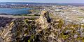
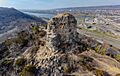
Sugar Loaf is a famous bluff in Winona, Minnesota. It stands tall above the Mississippi River and has a unique rock spike on top. People sometimes call just the rock spike "Sugar Loaf." This spike was actually made by people who were digging for rocks in the 1800s.
The bluff is located where two main roads meet: U.S. Route 61 and State Highway 43. It rises about 500 feet (152 meters) above Lake Winona, which used to be part of the Mississippi River. The rock spike itself is more than 85 feet (26 meters) taller than the rest of the bluff!
Sugar Loaf became a special historical place in 1990. It was important because it was a well-known landmark for early travelers and tourists. Many people took pictures of it and wrote about it in travel books.
The Rock Spike: How It Was Made

The special rock spike on Sugar Loaf was formed because of quarrying. This means people dug out large amounts of rock from the bluff. They did this for most of the 1880s. The rock they took was limestone, which was used to build sidewalks and stone buildings in Winona.
Two brothers, John and Stephen O'Dea, were in charge of this rock digging. Limestone was needed because many wooden sidewalks in the city had burned down in a big fire in 1862. After the fire, the city wanted stronger sidewalks. Miles of limestone sidewalks were put in before the year 1900. They worked so well that the city made a rule in 1890: all new sidewalks had to be made of stone. Buildings also started using this stone because of its cool look. The rock digging stopped in 1887.
Something unusual happened in March 2004. A lot of limestone broke off the side of the rock spike. It left a dark trail of rocks and rubble down the bluff. This pile of rocks stopped about 100 yards (91 meters) from the closest house. The rocks fell because water got into cracks, froze, and then thawed. This freezing and thawing slowly pushed the layers of stone apart, especially after a very wet winter.
Sugar Loaf's History and Legends

Before the rock spike was created, Sugar Loaf looked like a rounded half-dome with trees on top. It was very well known to early explorers, traders, and boat pilots on the river.
Native American stories say that the mountain was once the stone hat of a chief named Wapasha I. Another legend tells of a fight far upriver in Red Wing, Minnesota. In this story, a single bluff split into two parts: Barn Bluff stayed in Red Wing, and Sugar Loaf moved downriver to where it is now.
The name "Sugar Loaf" comes from how the bluff used to look. It reminded people of the cone-shaped blocks that sugar was sold in a long time ago. There are many other hills and mountains named "Sugar Loaf" in the United States, including a few others near the Mississippi River in Minnesota.
Today, several businesses near the bluff use "Sugar Loaf" in their names. There's even a neighborhood called Sugar Loaf, which sometimes appears as a small town on maps. The old Sugar Loaf Brewery building is also located on the side of the bluff. This brewery had caves that went into Sugar Loaf and is also a historical site.
Images for kids
-
Sugar Loaf from the back
-
Sugar Loaf from the side
-
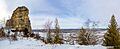
Sugar Loaf in winter


