
Sugar Pine, California facts for kids
Quick facts for kids
Sugar Pine
|
|
|---|---|

Sugar Pine
Location in California

Sugar Pine
Location in the United States
|
|
| Country | United States |
| State | California |
| County | Madera County |
| Elevation | 4,236 ft (1,291 m) |
Sugar Pine is a small, unincorporated community in Madera County, California. This means it's a place where people live, but it doesn't have its own local government like a city.
It is located about 5 miles (8 km) north of Yosemite Forks. Sugar Pine sits high up in the mountains, at an elevation of 4,236 feet (1,291 meters). You can find it about 1 mile (1.6 km) east of California State Route 41. It is located between the town of Oakhurst, California and the South Entrance of Yosemite National Park.
History of Sugar Pine
Sugar Pine was built a long time ago, between 1899 and 1900. It was created by a company called the Madera Sugar Pine Company. This company had a very large logging business in the area. They cut down trees and processed timber from the 1890s until 1931.
Today, most of the old mill is gone. Only the mill pond and a few service buildings remain. However, the houses that the company built for its workers are still used today. Many of them have been updated and are now homes or vacation spots.
A post office also operated in Sugar Pine for many years. It was open from 1907 until 1934.
Images for kids
-
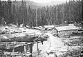
The first mill at Sugar Pine around 1920.
-
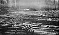
A "full deck" in the log pond ready to be cut.
-
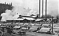
The Madera Sugar Pine company expanded the Sugar Pine Mill complex after a catastrophic fire in 1922.
-
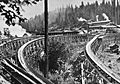
Several flume sections leave the mill to converge into one v-shaped trough for the 54-mile run to Madera, California.


