
Sunbury earth rings facts for kids

The Sunbury Earth Rings, also known as Bora Rings, are very old Aboriginal sites found on hills west of Jacksons Creek near Sunbury, Victoria, Australia. These special places were created by Aboriginal people long ago and are important parts of their history and culture.
Contents
What are the Sunbury Earth Rings?
These rings were made by carefully scraping away grass and topsoil, then piling it up to form a circular ridge around the outside. They are usually between 10 and 25 meters wide. There are three rings close to each other, and two more a few kilometers away. All of them are on gently sloping ground.
How are they different from other Bora Rings?
The Sunbury Earth Rings are a bit different from other Bora Rings found in New South Wales and southeast Queensland. Those rings are often hidden in flat areas and usually come in connected pairs. The Sunbury rings stand out because of their location and how they are arranged.
When were they discovered?
People started to notice and study the Sunbury Earth Rings in the early 1970s. An archaeologist named Dr. David Frankel did some digging at one of the rings to find out how they were made and what they were used for.
What did archaeologists find?
During the excavations, Dr. Frankel's team found the remains of two small stone piles, called cairns. One was in the center of the circle, and the other was on its edge. They also found several sharp stone blades or knives. These tools might have been used in important ceremonies or rituals that took place at the rings.
Protecting the Sunbury Earth Rings
It's very important to protect these ancient sites. Some of the rings are now looked after by the Wurundjeri Woi Wurrung Cultural Heritage Aboriginal Corporation. This group works to preserve Aboriginal culture and heritage. The rings are also listed on the Register of the National Estate, which means they are recognized as important historical places that need to be conserved.
Challenges to their preservation
Even with protection, the rings face challenges from new buildings and housing developments. For example, one ring is now surrounded by the back fences of houses. Another ring might soon be surrounded by roads because of new building plans. There was even an idea once to put one of the rings in the middle of a traffic roundabout! Groups like the Sunbury Maribyrnong Valley Green Wedge Defenders are working hard to protect these sites from being built over. They want to make sure these special places are safe for future generations.
Views of the Rings (around 2004)
-
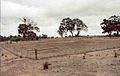
Hopbush Avenue Ring
-
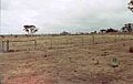
Correa Way Ring
-
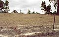
Wirilda Court Ring
-
Reservoir Road ring
-
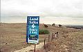
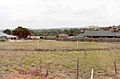
Riddells Road Ring (on far left) with a sign about future residential development


Where are the Rings located?
- Riddells Road Ring 37°33′12″S 144°42′11″E / 37.553419°S 144.703165°E
- Hopbush Ave Ring 37°33′44″S 144°44′29″E / 37.56225°S 144.74129°E
- Correa Way Ring 37°33′46″S 144°44′22″E / 37.562801°S 144.739434°E
- Wirilda Court Ring 37°33′52″S 144°44′08″E / 37.564323°S 144.735566°E
- Reservoir Road Ring 37°34′10″S 144°41′53″E / 37.569519°S 144.697926°E
