Talbot, Victoria facts for kids
Quick facts for kids TalbotVictoria |
|
|---|---|

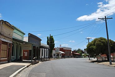
Scandinavian Crescent in Talbot
|
|
| Population | 442 (2016 census) |
| Postcode(s) | 3371 |
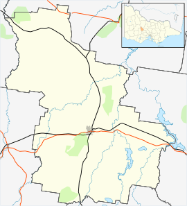
| Location | |
| LGA(s) | Shire of Central Goldfields |
| State electorate(s) | Ripon |
| Federal Division(s) | Mallee |
Talbot is a small town in Victoria, Australia. In 2016, about 442 people lived there. Talbot is known for its interesting history, especially during the gold rush days. Today, it's a quiet town that attracts visitors with its old buildings and a popular market.
Contents
History of Talbot: From Sheep to Gold
In September 1836, an explorer named Major Thomas Livingstone Mitchell visited the Talbot area. He said the land was perfect for raising sheep. The first settlers arrived in June 1841, with Alexander McCallum starting a large sheep farm. For about ten years, the area was mostly peaceful, with farmers and their sheep living quietly. But this calm scene was about to change forever.
The Gold Rush and Talbot's Growth
News of gold discoveries spread quickly across Australia and even to other countries. People from all over the world rushed to the area, hoping to find their fortune.
The first unofficial gold find nearby was at Daisy Hill. A shepherd named Thomas Chapman found it, but he kept it a secret. Official gold discoveries in Victoria began in 1851. The first official gold find near Talbot happened in 1852 at Daisy Hill Creek, which was later called Amherst. Two men, Cowley and John Potter, found a gold nugget while trying to free their stuck wagon. This discovery led to a big rush to Daisy Hill.
Miners soon started looking for gold around Back Creek. By 1854, many people had come to Amherst and Back Creek. Rich gold areas like Ballarat Hill and Nuggetty Gully were discovered. By early 1855, about 2,500 miners and shopkeepers lived at Back Creek, along with 300 women and children. With so many people arriving quickly, the town faced challenges in keeping everyone safe and organized.
Big Gold Finds and New Settlements
In March 1855, the "Goodwoman’s Hill" gold rush began. Miners found large nuggets, some weighing as much as 60 ounces (about 1.8 kilograms)! This led to more discoveries at Bakery Hill and Church Hill. In May 1855, Chinese miners arrived and set up camps. More gold rushes happened at places like Mount Greenock. Huge amounts of gold were found, with some nuggets weighing over 260 ounces (about 8 kilograms).
A water system was built to help miners use water to find gold, a process called sluicing. This system still helps supply water to Talbot today.
The next big event was the "Scandinavian Rush" in 1859. This rush truly created the town of Talbot as we know it. Miners like Carl Hallem and the Olsen brothers found the area "alive with gold." Many people arrived, setting up tents and digging for gold. The main street, Scandinavian Crescent, was formed in March 1859. It was named after the Scandinavian miners who made big discoveries.
By March 1859, an estimated 15,000 people were in the area. Hundreds of businesses opened on Scandinavian Crescent to serve the miners. Camp Street became a new road to Amherst. Newspapers like the 'Amherst and Back Creek Advertiser' started up. Permanent buildings began to replace tents. A post office, several banks, and a church were built. There were six streets filled with stores, including Oxford Street, Bond Street, and Russell Street. A theatre even opened in Oxford Street.
Working in the mines was dangerous, and miners faced risks, especially when using explosives to break through hard rock. But the promise of wealth kept them going. The town was full of noise and excitement from the many diggers. Stories of huge gold finds, like a 200-ounce (6-kilogram) gold cake in a shop window, seemed like fairy tales, but they were true!
In 1861-62, the town was officially surveyed. Records show that Scandinavian Crescent alone had 23 restaurants, many hotels, butchers, shoe shops, and chemists. This shows how many different services were available to the miners.
Talbot Becomes Official
The Scandinavian Rush slowed down by 1860, but it had created a thriving town. Many mining companies continued to operate, like the Great Extended Conway Castle and the Sadowa Co., which found about 60,000 ounces of gold!
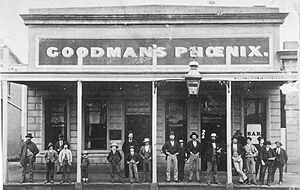
By 1864, Talbot had grown a lot. It had a Court House, seven schools, many shops, two breweries, churches, and sixteen hotels. It also had coach services and a population of about 3,400 people. On October 19, 1861, the Governor of Victoria, Sir Henry Barkly, officially named the town Talbot. The area continued to grow, and on October 31, 1865, the Shire of Talbot was created. The Post Office, which opened in 1854 as Back Creek, was renamed Talbot in 1862.
Many of the buildings you see in Talbot today were built in the 1860s and 1870s. In the late 1880s, the gold mines began to close, and people slowly started to leave. After the First World War, even more people moved away. Without many industries left, Talbot became much smaller than it was during the gold rush. However, Talbot still has a fascinating story to share. Recently, more people and businesses have been drawn to the town's history and beautiful old buildings, leading to a new wave of development.
Talbot Today
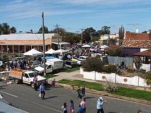
Talbot is now famous for its popular Farmers Market. Thousands of people visit the town on the third Sunday of every month for the market. The growing number of tourists in nearby areas like Daylesford and Avoca is helping Talbot. New restaurants and shops have opened recently, bringing more life back to the town.
The town also has an Australian Rules football team that plays in the Maryborough Castlemaine District Football League. Golfers can enjoy a game at the Talbot Golf Club on Lexton Road.
 | Percy Lavon Julian |
 | Katherine Johnson |
 | George Washington Carver |
 | Annie Easley |


