
Tamazula de Victoria facts for kids
Quick facts for kids
Tamazula de Victoria
|
||
|---|---|---|
|
Municipal seat and city
|
||
|
||

Tamazula de Victoria
Location in Durango

Tamazula de Victoria
Location in Mexico
|
||
| Country | ||
| State | Durango | |
| Municipality | Tamazula | |
| Elevation | 245 m (804 ft) | |
| Population
(2010)
|
||
| • Total | 2,337 | |
| Time zone | UTC-6 (CST) | |
| • Summer (DST) | UTC-5 (CDT) | |
| Postalcode |
34580
|
|
| Website | http://www.tamazuladgo.gob.mx/index.html | |
Tamazula de Victoria is a small town in the Mexican state of Durango. It is the main town and administrative center of the Tamazula area. The town is located about 85 kilometers (53 miles) east of Culiacán, Sinaloa. It sits in the Sierra Madre Occidental mountains, and the Tamazula River flows just north of the town.
Most people just call it Tamazula. The "de Victoria" part was added to its official name to honor Guadalupe Victoria. He was the first president of Mexico, and he was born in Tamazula. His brother, Francisco Victoria, was also born here. In 2010, about 2,337 people lived in the town.
History of Tamazula
In the 1600s, a group of missionaries called the Jesuits started a mission here. They named it Mission San Ignacio de Tamazula.
Villages in Tamazula
The Tamazula area includes several smaller villages. These are:
- Amaculi
- Los Remedios
- El Chicural
- El Cocoyole
- Chacala
- El Llano
- El Comedero
- Las Juntas
- Las Quebradas
- El Río
- Pueblo Viejo
- El Carrizo
- Otatitlán
- Las Coloradas
- Santa Elena
- El Cajón
- La Mesa del Rodeo
- El Durazno
- La Alameda
- Santa Gertrudis
- El Tecuán
- Santa Barbara
- Cuesta Blanca
Gallery
-
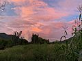
Cactus Cardon Guajiro and Corn at Sunset after a summer thunderstorm in Tamazula, Durango
-
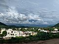
Hillside view looking East
-
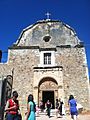
Templo San Ignacio de Layola Catholic Church
-
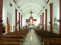
Interior view of San Ignacio de Layola Catholic Church altar in 2013
-
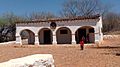
1786 Birthplace and childhood home of Guadalupe Victoria. Now a museum


See also
 In Spanish: Tamazula de Victoria para niños
