Tandjilé (region) facts for kids
Quick facts for kids
Tandjilé
تانجلي
|
|
|---|---|

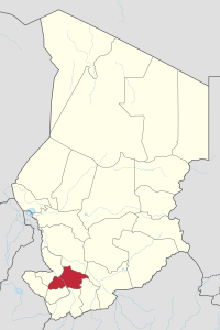
Map of Chad showing Tandjilé.
|
|
| Country | Chad |
| Departments | 2 |
| Sub-prefectures | 13 |
| Regional capital | Laï |
| Population
(2009)
|
|
| • Total | 661,906 |
Tandjilé (Arabic: تانجلي) is one of the 23 regions in the country of Chad. It is located in the south-west part of Chad. The main city and capital of Tandjilé is Laï. This region used to be known as the Tandjilé prefecture.
Contents
Where is Tandjilé Located?
The Tandjilé region shares its borders with several other regions of Chad. To the north, it borders the Chari-Baguirmi Region. To the east, you'll find the Moyen-Chari Region and Mandoul Region. South of Tandjilé are the Logone Occidental Region and Logone Oriental Region. Finally, to the west, it borders the Mayo-Kebbi Ouest Region and Mayo-Kebbi Est Region.
Main Towns and Cities
The biggest city and capital of the Tandjilé region is Laï. Other important towns in the area include Baktchoro, Béré, Dafra, Déressia, Dono Manga, Guidari, Kélo, and N'Dam.
Who Lives in Tandjilé?
According to a census taken in Chad in 2009, the total number of people living in Tandjilé was 661,906. Back in 1993, there were 458,240 people. Most of these people (442,876) lived in settled communities, either in rural areas (385,537) or in towns (57,339). About 15,364 people were nomads, meaning they moved from place to place.
Many different groups of people live in Tandjilé. They speak various languages. Some of the main groups include the Besme, Gabri, Goundo, Kabalai, Kim, Kimré, Kwang, Lele, Mango, Marba, Mesme, Mire, Nangtchéré, Ndam, the Sara Ngambay, Somrai, Tobanga, and Tumak people.
How Tandjilé is Organized
The Tandjilé region is divided into two main parts called departments. Each department has its own capital city and several smaller areas called sub-prefectures.
| Department | Capital (chef-lieu) | Sub-prefectures |
|---|---|---|
| Tandjilé Est | Laï | Laï, Deressia, Dono Manga, Guidari, N'Dam |
| Tandjilé Ouest | Kélo | Kélo, Baktchoro, Béré, Bologo, Dafra, Delbian, Dogou, Kolon |
See also
 In Spanish: Región de Tandjilé para niños
 | Jessica Watkins |
 | Robert Henry Lawrence Jr. |
 | Mae Jemison |
 | Sian Proctor |
 | Guion Bluford |

