
Tankerton Slopes facts for kids
| Site of Special Scientific Interest | |
 |
|
| Area of Search | Kent |
|---|---|
| Coordinates | 51°21′50″N 1°02′42″E / 51.364°N 1.045°E |
| Interest | Biological |
| Area | 2.3 hectares (5.7 acres) |
| Notification | 1986 |
| Location map | Magic Map |
Tankerton Slopes is a special natural area in Whitstable, Kent, covering about 2.3 hectares (that's like 5.7 acres!). It's known as a Site of Special Scientific Interest (SSSI) because of its unique plants and animals. It's also part of a bigger protected area called the Tankerton Slopes and Swalecliffe Special Area of Conservation.
This beautiful area is a great spot for exploring nature and enjoying views of the sea. You can easily get to the site from Tankerton Beach. The slopes are about 15 meters (50 feet) high from the promenade, or 20 meters (66 feet) above sea level.
Contents
What Makes Tankerton Slopes Special?
Tankerton Slopes faces north, which helps special plants grow here. It's home to a large group of a rare plant called hog's fennel. This plant is a type of umbellifer, which means its flowers grow in umbrella-like clusters.
Unique Wildlife
This special plant is very important for a rare moth called agonopterix putridella. The young moths (larvae) only eat hog's fennel! This makes Tankerton Slopes a vital place for this unique insect to live and grow.
Exploring the Slopes
At the bottom of the slopes, you'll find colorful Beach huts. There's also a promenade, which is a path that runs all the way from Whitstable to Swalcliffe. It's a popular place for people to walk their dogs or ride bikes.
The Tankerton Beacon
If you walk to the top of the slope on the west side, you'll see a beacon. This beacon works by having a wood fire in a basket placed on top of a tall wooden post. It's a cool sight to see!
Amazing Views
From Tankerton Slopes, you can see some interesting things in the distance:
- The "red sands" Maunsell Forts in the Thames Estuary. These are old forts that stand in the water.
- The thirty wind turbines of the Kentish Flats Offshore Wind Farm. These giant turbines help create clean energy from the wind.
- From the west end, you can see "The Street." This is a "spit of land" made of shingle that appears when the tide is low. You can even walk about 750 meters (nearly half a mile) out into the sea on it!
Gallery
-
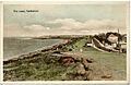
Tinted photograph on postcard dated around 1905-1914 showing "The Leas"
-
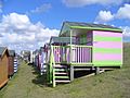
Colourful rows of wooden huts on the grassy slopes of "Tankerton slopes" below Marine Parade
-

Sunset from Tankerton Slopes towards Sheppey
-
Tankerton Beacon
-

Tankerton Slopes as seen from "The Street"


.jpg)
