
Tater Du Lighthouse facts for kids
.jpg) |
|
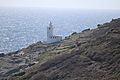
| Tater Du Lighthouse in 2013 | |

Tater Du Lighthouse
Location in Cornwall
|
|
| Location | Penzance Cornwall England |
|---|---|
| Coordinates | 50°03′09″N 5°34′39″W / 50.052394°N 5.577372°W |
| Year first constructed | 1965 |
| Automated | 1965 |
| Construction | concrete block tower |
| Tower shape | cylindrical tower with balcony and lantern |
| Markings / pattern | white tower and lantern |
| Height | 15 metres (49 ft) |
| Focal height | 34 metres (112 ft) |
| Current lens | 4th Order 250Mm Rotating Catadioptric Optic |
| Intensity | 96,000 candela |
| Range | 20 nautical miles (37 km; 23 mi) |
| Characteristic | Fl (3) W 15s. |
| Admiralty number | A0032 |
| NGA number | 0032 |
| ARLHS number | ENG 152 |
Tater Du Lighthouse is the newest lighthouse built in Cornwall, England. It was built because of a sad event in 1963. A small Spanish cargo ship, the Juan Ferrer, sank near Boscawen Point, and 11 people lost their lives. After this, local fishermen asked Trinity House, the group that manages lighthouses, to build a new light. They wanted to prevent similar accidents. The lighthouse, made from concrete blocks, first shone its light in July 1965.
Contents
What Does Tater Du Lighthouse Look Like?
The lighthouse is a short building with a special light at the top. This light is electric and gets its power from batteries. The batteries charge up using electricity from the main power grid during the day.
The main light flashes three white lights every 15 seconds. Its light can be seen up to 20 nautical miles (37 km; 23 mi) away. There is also a separate red light that shines from a lower window. This red light helps guide ships away from a dangerous spot called the Runnelstone Rock.
The lighthouse also watches over two rocks called the Inner and Outer Bucks. These rocks are partly hidden at low tide. A ship called the SS Garonne was lost near these rocks in 1868.
How Has Tater Du Lighthouse Changed Over Time?
The Tater Du Lighthouse was designed by Michael H. Crisp. When it was first built, it was completely automatic. This meant no one had to live there to operate it. It was controlled from a Trinity House office in Penzance.
In 1997, the lighthouse was updated with newer technology. Now, it is watched over from the Trinity House Planning Centre in Harwich. This allows people to check on the lighthouse from far away.
Fog Signal: A Sound for Safety
Lighthouses often have fog signals to help ships when it's foggy and they can't see the light. Tater Du Lighthouse used to have a special fog signal. It had many speakers built into the tower that made a loud sound. This sound was two short blasts, each lasting one second, every 30 seconds.
Later, the old fog signal was replaced with a newer, electric one. However, the fog signal at Tater Du Lighthouse was turned off in 2012.
What's Around Tater Du Lighthouse?
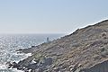
The cliffs and slopes around the lighthouse are a very special place. They are called the Tater–du SSSI, which stands for "Site of Special Scientific Interest." This area was given this special title in 1992. It's important because it shows unique clues about the Earth's history in southwest England. Scientists can study the rocks here, especially the "pillow lavas," to learn about how the land was formed long ago.
The rocks nearby, the Inner and Outer Bucks, are a popular spot for people who like to go diving underwater. Divers often launch their boats from Penzance to explore these rocks.
Images for kids
-
A distant view of Tater Du Lighthouse
-
Tater Du Lighthouse
-
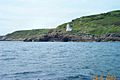
The coast at Tater Du
-
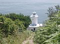
The steep access road down to the lighthouse


