
Teapot Rock facts for kids
Quick facts for kids |
|
|
Teapot Rock
|
|

Teapot Rock in 2017, from the west.
|
|

Location in Wyoming

Location in the United States
|
|
| Location | Natrona County, Wyoming, USA |
|---|---|
| Nearest city | Midwest, Wyoming |
| Built | 1922 |
| NRHP reference No. | 74002028 |
| Added to NRHP | December 30, 1974 |
Teapot Rock is a cool rock formation in Natrona County, Wyoming. It looks a bit like a teapot! This rock gave its name to a nearby oil field. This oil field was part of a big scandal long ago called the Teapot Dome scandal. Teapot Rock is now a special historical site. It was added to the National Register of Historic Places in 1974.
What is Teapot Rock?
Teapot Rock is a natural rock formation. It is made of sandstone that has been shaped by wind and water. This process is called erosion. The rock is about 75 feet (23 meters) tall. It measures about 300 feet (91 meters) around its base. You can find it in Natrona County, Wyoming. It is a few hundred yards east of Wyoming Highway 259. The rock is about 19 miles (31 km) north of Casper, Wyoming. It is located in the Powder River Basin near Teapot Creek. Its unique shape reminded people of a teapot. This is how it got its name.
The Teapot Dome Scandal
The Teapot Dome scandal was a big event in American history. It happened in the 1920s. The scandal was about the Teapot Dome oil field. This oil field was named after Teapot Rock. The oil field was owned by the United States government. It was meant to be a special fuel reserve for the U.S. Navy.
In 1915, the U.S. Navy started changing its ships. They began using oil-fired boilers instead of coal. So, the Navy needed a lot of oil. The Teapot Dome Oil Field was set aside for them. It was called "Naval Petroleum Reserve Number Three." This was to make sure the Navy always had enough fuel, especially in emergencies. There were other oil fields nearby, like the much larger Salt Creek Oil Field.
The scandal happened when the Secretary of the Interior, Albert Fall, secretly leased the oil field. He leased it to private oil companies. He did this without getting bids from other companies. He also took money from the oil companies. This was a form of bribery. The scandal showed how some government officials were not honest. It was a big deal at the time.
Images for kids
-
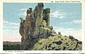
Teapot Rock on an old postcard

