Tennessee water resource region facts for kids
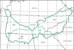
The Tennessee water resource region is like a big natural neighborhood defined by water! It's one of 21 main areas that the United States Geological Survey (USGS) uses to organize all the water systems in the United States. Think of these regions as large sections of land where all the rain and snow eventually flow into one major river or a group of rivers.
The Tennessee region has a special code, 06, which helps scientists keep track of it. This area is about 40,908 square miles (106,000 km2) big! It's divided into 4 smaller sections called subregions, each with its own 4-digit code from 0601 to 0604.
This important region includes all the land where water flows into the Tennessee River. It covers parts of several states: Alabama, Georgia, Kentucky, Mississippi, North Carolina, Tennessee, and Virginia.
Exploring the Tennessee Water Subregions
The Tennessee water resource region is divided into four main subregions. Each subregion has its own unique features and covers different parts of the states. These smaller areas help us understand how water flows through the land and where it eventually goes.
| Subregion Code | Subregion Name | What it Includes | States Covered | Size | Map |
|---|---|---|---|---|---|
| 0601 | Upper Tennessee Subregion | This is the part of the Tennessee River Basin that is above the Watts Bar Dam. | Georgia, North Carolina, Tennessee, and Virginia. | 17,200 sq mi (45,000 km2) | |
| 0602 | Middle Tennessee-Hiwassee Subregion | This section of the Tennessee River Basin is below Watts Bar Dam and includes the Sequatchie River Basin. | Alabama, Georgia, North Carolina, and Tennessee. | 5,160 sq mi (13,400 km2) | |
| 0603 | Middle Tennessee-Elk Subregion | This part of the Tennessee River Basin is below where it meets the Sequatchie River Basin, all the way to Pickwick Dam. | Alabama, Georgia, Mississippi, and Tennessee. | 10,300 sq mi (27,000 km2) | |
| 0604 | Lower Tennessee Subregion | This is the lowest part of the Tennessee River Basin, found below Pickwick Dam. | Kentucky, Mississippi, and Tennessee. | 8,010 sq mi (20,700 km2) |
 | Jewel Prestage |
 | Ella Baker |
 | Fannie Lou Hamer |


