
Thiel Mountains facts for kids
Quick facts for kids Thiel Mountains |
|
|---|---|

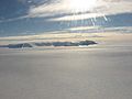
Aerial view of the Thiel Mountains
|
|
| Highest point | |
| Peak | Anderson Summit |
| Elevation | 2,810 m (9,220 ft) |
| Dimensions | |
| Length | 72 km (45 mi) |
| Area | 71,578 km2 (27,636 sq mi) |
| Geography | |

Thiel Mountains
Location in Antarctica
|
|
| Continent | Antarctica |
| Parent range | Transantarctic Mountains |
|
Thiel Skiway
|
|||||||||||
|---|---|---|---|---|---|---|---|---|---|---|---|

Thiel Mountains refueling depot
|
|||||||||||
| Summary | |||||||||||
| Airport type | Private | ||||||||||
| Location | Thiel Mountains Ellsworth Land |
||||||||||
| Coordinates | 85°11′56″S 87°52′18″W / 85.198883°S 87.871803°W | ||||||||||
| Map | |||||||||||

Thiel Skiway
Location in Antarctica
|
|||||||||||
| Runway | |||||||||||
|
|||||||||||
The Thiel Mountains are a group of mountains in Antarctica. They are mostly covered in snow and stand alone in the vast icy landscape. These mountains are part of the larger Transantarctic Mountains System. You can find them in the Ellsworth Land region of Antarctica.
The mountain range is about 72 km (45 mi) long. It stretches between the Horlick Mountains and the Pensacola Mountains. On the west side, it starts at Moulton Escarpment and goes all the way to Nolan Pillar on the east.
Contents
Exploring the Thiel Mountains
The Thiel Mountains have several important parts. These include Ford Massif, which is the highest point at 2,810 meters (9,219 feet). There is also Bermel Escarpment and a cluster of peaks near Nolan Pillar.
First Discoveries and Surveys
The Thiel Mountains were first seen and mapped by a group called the USARP Horlick Mountains Traverse Party. This happened during their expedition in 1958-1959. Later, the United States Geological Survey (USGS) sent teams to survey the mountains. These surveys took place in 1960-1961 and again in 1961-1962.
How the Mountains Got Their Name
The mountains were named by the Advisory Committee on Antarctic Names (US-ACAN). They chose to honor Dr. Edward C Thiel. Dr. Thiel was a scientist who studied earthquakes (a seismologist). He worked at Ellsworth Station and in the Pensacola Mountains in 1957.
In December 1959, Dr. Thiel flew over the area. He collected important scientific information, including near these mountains. Sadly, Dr. Thiel passed away in an aircraft accident on November 9, 1961. He was with four other people when their plane crashed after taking off from Wilkes Station.
Thiel Mountains Skiway
Near the Thiel Mountains, there is a special place called the Thiel Skiway. It's not a regular airport, but a private skiway on the ice. This skiway is used as a fuel stop for planes. These planes travel between the Union Glacier Camp and the Amundsen–Scott South Pole Station. It's like a gas station for airplanes in the middle of Antarctica! The fuel cache is located at 85°12′S 087°53′W / 85.200°S 87.883°W.
Images for kids
-
Distant aerial view of the Thiel Mountains

See also
 In Spanish: Cordillera Thiel para niños
