
Tjukurla Community facts for kids
Quick facts for kids TjukurlaWestern Australia |
|
|---|---|

Tjukurla
Location in Western Australia
|
|
| Postcode(s) | 6642 |
| Area | [convert: needs a number] |
| Time zone | ACST (UTC+9:30) |
| Location | 350 km (217 mi) north east of Warburton |
| LGA(s) | Shire of Ngaanyatjarraku |
| State electorate(s) | North West Central |
| Federal Division(s) | O'Connor |
Tjukurla is a special Aboriginal community located in the Goldfields-Esperance area of Western Australia. It is found within the Shire of Ngaanyatjarraku.
Contents
History of Tjukurla
In the early 1980s, people started moving to areas closer to their traditional lands. This was part of a movement called the "outstation movement." A bore (a deep hole for water) was dug near where Tjukurla is today.
In mid-1981, an outstation was set up at Kintore. This allowed people living at Papunya to move west. As Tjukurla grew, many people moved there from Kintore. Others also came from Warakurna, Docker River, and some from Warburton.
Native Title and Land Rights
The Tjukurla community is located on land that has been recognized under Native Title. This means the Ngaanyatjarra people have special rights to their traditional lands. This area is known as the Ngaanyatjarra Lands (Part A).
How Tjukurla is Managed
The community of Tjukurla is managed by its own group called the Tjukurla Community Aboriginal Corporation. This group was officially formed on February 17, 1987. They help make decisions and manage things for the community.
Planning the Community
There is a plan called Tjukurla Layout Plan No.1. This plan helps organize how the community is set up and developed. It follows special rules for Aboriginal settlements. The community is still working to approve this plan.
Images for kids
-
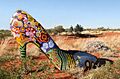
The turnoff to Tjukurla is marked by this large shoe sculpture with Aboriginal art.

