Shire of Ngaanyatjarraku facts for kids
Quick facts for kids Shire of NgaanyatjarrakuWestern Australia |
|||||||||||||||
|---|---|---|---|---|---|---|---|---|---|---|---|---|---|---|---|

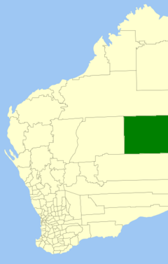
Location in Western Australia
|
|||||||||||||||
| Area | 160,732.9 km2 (62,059.3 sq mi) | ||||||||||||||
| Shire President | Damian McLean | ||||||||||||||
| Council seat | Warburton | ||||||||||||||
| Region | Goldfields-Esperance | ||||||||||||||
| State electorate(s) | North West Central | ||||||||||||||
| Federal Division(s) | O'Connor | ||||||||||||||
 |
|||||||||||||||
| Website | Shire of Ngaanyatjarraku | ||||||||||||||
|
|||||||||||||||
The Shire of Ngaanyatjarraku is a very large area in Western Australia. It is far away from big cities like Perth, about 1,542 kilometers (958 miles) away. This Shire is close to the borders of the Northern Territory and South Australia.
A "Shire" is like a local council that manages an area. This Shire was created on July 1, 1993. Before that, it was part of the Shire of Wiluna, but the eastern part became the new Ngaanyatjarraku Shire.
This area is the traditional home of the Ngaanyatjarra people. The boundaries of the Shire are the same as the land leased by the Ngaanyatjarra Land Council for the traditional owners.
The Shire has 560 kilometers (348 miles) of gravel roads. It is very far from any paved roads.
In 2005, the Federal Court of Australia recognized the native title claim over a huge area of land. This land, about 187,700 square kilometers (72,500 square miles), is roughly the size of Syria. It is located in the Central Desert region, covering parts of the Shire of Laverton and the Shire of Ngaanyatjarraku.
For most people living here, the Ngaanyatjarra language is their first language. Another important language spoken is Pitjantjatjara.
Contents
Who Lives Here?
The ABS Census in 2021 showed that 1,358 people live in the Shire.
- About 84.5% of the people are Indigenous Australians.
- The community has more young people than the rest of Australia. The average age is 30 years, while for all of Australia it is 38 years.
Languages Spoken at Home
- About 71.4% of people (970 residents) speak Ngaanyatjarra at home.
- Only 9.9% of people speak only English at home. This is much lower than the 72.0% across all of Australia.
Communities and Towns
The Shire of Ngaanyatjarraku covers a huge area of 159,948 square kilometers (61,756 square miles). The local government is in charge of providing services to the communities here. There are 10 small local centers within the Ngaanyatjarra Lands.
Here are the communities and towns in the Shire, with their populations and sizes from the latest Australian census:
| Locality | Population | Area | Map |
|---|---|---|---|
| Gibson Desert South | 4 (SAL 2021) | [convert: needs a number] | |
| Irrunytju | 133 (SAL 2021) | [convert: needs a number] | |
| Kanpa Community | 0 (SAL 2021) | [convert: needs a number] | |
| Mantamaru Community | 124 (SAL 2021) | [convert: needs a number] | |
| Ngaanyatjarra-Giles | 43 (SAL 2021) | [convert: needs a number] | |
| Papulankutja Community | 162 (SAL 2021) | [convert: needs a number] | |
| Patjarr Community | 39 (SAL 2021) | [convert: needs a number] | |
| Tjirrkarli Community | 4 (SAL 2021) | [convert: needs a number] | |
| Tjukurla Community | 41 (SAL 2021) | [convert: needs a number] | |
| Wanarn Community | 117 (SAL 2021) | [convert: needs a number] | |
| Warakurna Community | 185 (SAL 2021) | [convert: needs a number] | |
| Warburton | 511 (SAL 2021) | [convert: needs a number] |
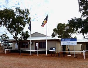
Some other places like Kiwirrkurra and Yilka (Cosmo Newbery) are not within the Ngaanyatjarra Lands, but the Shire still provides services to them. The Giles Weather Station is also located within the Shire.
Council Information
The Shire of Ngaanyatjarraku is located in the Gibson and Great Victoria Deserts.
- It has 12.6 kilometers (7.8 miles) of paved roads.
- It has 1,444 kilometers (897 miles) of unpaved roads.
- In 2006, the population was 1,335 people.
- There is 1 college and 8 primary and high schools (Kindergarten to Year 10).
Ngaanyatjarra Council (Aboriginal Corporation)
The Ngaanyatjarra Council is a separate organization that works closely with the Shire. It helps manage many important services for the communities, such as:
- Air services (often working with Missionary Aviation Fellowship (MAF)).
- Tertiary education (like the Ngaanyatjarra Community College in Warburton).
- Managing the communities.
- Looking after the land.
- Representing Native Title interests.
- Running Ngaanyatjarra Agencies and Transport Services Inc (NATS).
- Operating Ngaanyatjarra Services (Aboriginal Corporation).
- Managing roadhouses, which are places where travelers can get fuel and supplies. These include:
- Tjukayirla
- Warakurna
- Warburton
- Running service stations. For example, a Caltex fuel franchise in Alice Springs supplies fuel to all Ngaanyatjarra communities, workshops, and roadhouses.
Historic Places
As of 2023, there are two places in the Shire of Ngaanyatjarraku that are recognized for their history. These are the Giles Meteorological Station and the Warakurna Multi-Function Police Facility. Neither of these places are on the official State Register of Heritage Places.
 | DeHart Hubbard |
 | Wilma Rudolph |
 | Jesse Owens |
 | Jackie Joyner-Kersee |
 | Major Taylor |


