
Deserts of Australia facts for kids
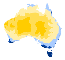
Quick facts for kids Great Australian Desert |
|
|---|---|

|
|

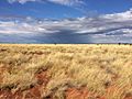
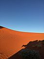
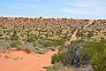
Typical landscape (Simpson Desert)
|
|
| Length | 4,710 km (2,930 mi) |
| Width | 1,890 km (1,170 mi) |
| Area | 2,700,000 km2 (1,000,000 sq mi) |
| Geography | |
| Country | Australia |
| States |
List
|
The deserts of Australia are also known as the Great Australian Desert. They cover about 2.7 million square kilometers, which is about 18% of Australia's land. However, about 35% of the Australian continent gets so little rain that it's almost a desert. These deserts are mostly found in the western and central parts of the country. They stretch across many states, including South West Queensland, New South Wales, Victoria, South Australia, Northern Territory, and Western Australia.
Even though it's a desert, the Great Australian Desert gets a fair amount of rain, around 250 millimeters (10 inches) each year. But because the weather is so hot, a lot of this water evaporates quickly. No weather station in an Australian desert records less than 100 millimeters (4 inches) of rain per year. The deserts in the middle and south don't get much rain in summer. The desert in Western Australia is dry because of a cold ocean current that stops rain clouds from forming. About 40% of Australia is covered by sand dunes. Australia is the driest continent where people live, and its soils are not very fertile.
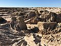
The Great Australian Desert is mostly empty of people, but it's full of different landscapes. You can find grassy areas, rocky plains, red sand dunes, and salt flats. There are also open forests and bushlands with a few rivers and salt lakes. Most of these lakes dry up at certain times of the year. This huge desert, covering 3 million square kilometers, is one of the most untouched places on Earth. It's also home to the largest group of wild camels in the world.
Contents
History of the Australian Deserts
Geological History

The rocks in Australia's desert areas are incredibly old, some more than 3.8 billion years old! This means they are among the oldest rocks on Earth. Australia has three main ancient rock foundations called cratons: the Yilgarn, Pilbara, and Gawler cratons. These huge, stable blocks of Earth's crust came together over billions of years to form the Australian landmass.
For example, the Capricorn Orogeny helped join the Yilgarn and Pilbara cratons in Western Australia. Other ancient rock belts connect the Yilgarn and Gawler cratons. These areas are now covered by younger sedimentary basins, which are like giant bowls filled with layers of rock and sediment.
Aboriginal History in the Deserts

Indigenous Australians have lived in the desert for at least 50,000 years. They lived in all parts of the Outback, even the driest deserts, when Europeans first arrived in the 1800s. Many Indigenous Australians still have strong connections to their traditional lands. They are legally recognized as the traditional owners of large parts of the Outback.
Aboriginal tribes and clans have moved around the desert areas for thousands of years. They found food from local plants and animals, known as bush food. They also made sure their water sources were safe. These groups moved within their own tribal areas. Important tribes living in the desert include the Arrernte, Luritja, and Pitjantjatjara people. The Pitjantjatjara's land stretched from Uluṟu to the Nullarbor Plain.
The rock art site at Karnatukul shows that people lived there for up to 25,000 years. This is one of the oldest known places where people lived continuously in the Western Desert. The oldest rock art in Western Australia and South Australia is about 40,000 years old.
For a long time, these isolated desert areas remained untouched by modern society. For instance, the Spinifex people first met white people in the 1950s. This happened when they were moved from their lands due to nuclear weapons tests. In 1984, the Pintupi Nine, a group of Aboriginal people, were found living in the Gibson Desert just as their ancestors had for thousands of years. These discoveries were very surprising at the time.
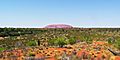
Large parts of the Australian deserts are important cultural areas for Aboriginal people. Places like Uluṟu and Kata Tjuṯa are very special to them because of their Dreamtime stories. Many famous Aboriginal artists, like Albert Namatjira, came from the desert regions. Today, about one-third of Australia's deserts are Aboriginal lands. Many of these areas are managed by them as nature reserves. Many Aboriginal people now live in settlements in the deserts.
European Exploration

The Strzelecki Desert was named in 1845 by explorer Charles Sturt. He named it after a Polish explorer, Paul Edmund Strzelecki.
The first European to cross the Great Sandy Desert was Peter Egerton Warburton. He barely survived, arriving on the coast exhausted and blind in one eye. He was saved by an Aboriginal tracker named Charley. Another British explorer, Ernest Giles, named the Great Victoria Desert in 1875 after Queen Victoria. From 1858 onwards, "Afghan" cameleers and their camels were very important. They helped open up the Outback and build roads and telegraph lines.
The Sturt Stony Desert was named by Charles Sturt in 1844. He was looking for a large inland sea he thought was in the middle of Australia. In 1865, a surveyor named George Goyder drew a line in South Australia. North of this line, he believed there wasn't enough reliable rain for farming. Ernest Giles named the Gibson Desert to remember Alfred Gibson, who disappeared during an expedition in 1873–74.
The Tanami Desert got its name from explorer Allan Davidson in 1900. "Tanami" was the Aboriginal name for two rock caves with fresh drinking water.
The Simpson Desert was named after Allen Simpson, a geographer. In 1936, Edmund Colson was the first white person to cross the Simpson Desert. Before him, famous explorers like Charles Sturt and David Lindsay had tried and failed. While early explorers used horses, the first woman to ride a horse across the Outback was Anna Hingley in 2006.
Regions of the Australian Desert


Australia has several large desert areas. In the west, the Tanami, Great Sandy, Little Sandy, Gibson, and Great Victoria deserts form one big area. In the east, the Simpson, Sturt, Strzelecki, and Tirari deserts form another. The small Pedirka Desert is located between the Great Victoria and Simpson deserts. The Little Sandy Desert is very similar to the Great Sandy Desert in its landscape. The Western Desert is a cultural area for Indigenous people. It includes the Gibson, Great Victoria, Great Sandy, and Little Sandy deserts.
Most people living in these desert areas are Indigenous Australians. There are also smaller desert-like places in Australia. For example, Kangaroo Island has a small area called the Little Sahara with sand dunes. In Victoria, there's the Little Desert National Park. The Painted Desert in South Australia is known for its colorful hills.
The Nullarbor Plain in southern Australia is a vast, flat area made of limestone. It is also sometimes called the Nullarbor Desert.
| Desert | State/Territory | Area (km2) | Area (miles2) | Area rank | % of Australia |
|---|---|---|---|---|---|
| Great Victoria Desert | South Australia Western Australia |
348,750 km2 | 134,650 sq mi | 1 | 4.5% |
| Great Sandy Desert | Northern Territory Western Australia |
267,250 km2 | 103,190 sq mi | 2 | 3.5% |
| Tanami Desert | Northern Territory Western Australia |
184,500 km2 | 71,200 sq mi | 3 | 2.4% |
| Simpson Desert | Northern Territory Queensland South Australia |
176,500 km2 | 68,100 sq mi | 4 | 2.3% |
| Gibson Desert | Western Australia | 156,000 km2 | 60,000 sq mi | 5 | 2.0% |
| Little Sandy Desert | Western Australia | 111,500 km2 | 43,100 sq mi | 6 | 1.5% |
| Strzelecki Desert | New South Wales Queensland South Australia |
80,250 km2 | 30,980 sq mi | 7 | 1.0% |
| Sturt Stony Desert | Queensland South Australia |
29,750 km2 | 11,490 sq mi | 8 | 0.3% |
| Tirari Desert | South Australia | 15,250 km2 | 5,890 sq mi | 9 | 0.2% |
| Pedirka Desert | South Australia | 1,250 km2 | 480 sq mi | 10 | 0.016% |
Geography of the Deserts
.jpg)

.jpg)


Deserts can be formed in different ways. Australian deserts are mostly "continental" (far from oceans), "tropical" (due to global weather patterns), or "shelter" deserts (blocked by mountains). Some coastal desert areas also exist in Western Australia. Cold ocean currents also play a big role in keeping parts of the continent dry. Millions of years ago, there were even cold or icy deserts in Australia, which helped shape some of the amazing rock formations we see today.
Many parts of the desert, like the Simpson Desert, have landscapes of rocky, burnt-looking ground called gibbers. Explorer Ernest Giles noted that large areas are covered in gravel with thin desert grasses. There are also wide areas of red sand plains and dunes. The sandy soil in the Gibson Desert is rich in iron. Some isolated salt lakes are found in the center of the region. Most of the desert is not suitable for living, so it remains largely untouched. The edges of the desert are sometimes used for sheep grazing.
Waterbodies in the Desert
The desert has many lakes, but most of them are dried-up salt lakes. These include:
- Menindee Lakes
- Willandra Lakes Region
- Lake Mungo
- Peery Lake
- Lake Amadeus
- Lake Mackay
- Lake Neale
- Numby Numby
- Lake Sylvester
- Tarrabool Lake
- Lake Woods
- Lake Yamma Yamma
- Lake Bumbunga
- Lake Dey Dey
- Lake Dutton
- Kati Thanda–Lake Eyre
- Lake Frome
- Lake Gairdner
- Lake Gilles
- Goyder Lagoon
- Lake Gregory
- Lake Hope
- Sleaford Mere
- Lake Torrens
- Serpentine Lakes
- Lake Maitland
- Lake Carnegie
- Lake Way
- Lake Macleod
- Lake Anneen
- Lake Barlee
- Lake Breaden
- Lake Burnside
- Lake Carey
- Lake Dora
- Dumbleyung Lake
- Lake Nabberu
- Serpentine Lakes
- Kumpupintil Lake
- Lake Ballard
- Lake Lefroy
- Lake Gregory
Rivers and creeks in the Australian desert are few and far between. They often only flow after rain. Some of these include:
- Darling River
- Alberga River
- Finke River
- Georgina River
- Hale River
- Alligator Rivers
- Mary River
- Todd River
- Diamantina River
- Gawler River
- Macumba River
- Warburton River
- Fitzroy River
- Leichhardt River
Life in the Australian Desert
Desert Plants

Two main types of grasslands grow in the Australian deserts. Tussock or Mitchell grasslands are found in the Northern Territory, South Australia, and Queensland. These grasses grow on clay soils that get 150 to 500 millimeters (6 to 20 inches) of rain. Trees don't grow well here, and bushfires are common. Spinifex or hummock grasslands have spiky grasses that grow in clumps.
On the sand dunes of the Simpson, Strzelecki, and Tirari deserts, a grass called Zygochloa is common. Many desert areas have semi-desert grasslands with mulga bushes (Acacia aneura). These low-growing acacia trees cover large areas in the south of the dry zone. They grow on plains, mountains, and hills. When bushfires, often started by spinifex grasses, burn the mulga bushes, they don't grow back easily.
Eucalyptus trees grow along dry riverbeds. Underneath them, you'll find grasses. Chenopodiaceae shrubs, which are usually short, grow in the southern desert areas. These are salt-tolerant plants that can grow in dry or salty soils. In rocky areas or sandstone canyons, you might find small, permanent patches of freshwater. Bluebush and saltbush species grow in heavier soils. Between the sand dunes, there are wooded areas with eucalyptus and acacia shrubs, along with tough spinifex grasses.
In very dry areas, plants like Old Man Saltbush and Cottonbush form sparse shrublands. Swamps and wet areas often have Swamp Cane-grass. Rivers like Cooper Creek support woodlands with River Red Gum and Coolibah trees. Many salt lakes form after heavy rain, like Lake Eyre, which fills up completely about once every 25 years. The desert also has 17 natural springs fed by the Great Artesian Basin, one of the world's largest freshwater sources. These springs are home to unique fish and rare plants.
-
The Great Sandy Desert seen from space.
-
Tussock grass in the Gibson Desert.
-
A kangaroo in Nambung National Park.
-
The Simpson Desert near Bedourie.
-
A red sand dune in the Simpson Desert.
-
An old railway line near Lake Eyre South, South Australia.
-
Desert savannah near Birdsville, Queensland.
-
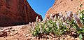
Desert flowers near Uluru.


_--_trackbed_near_Lake_Eyre_South,_South_Australia_(cropped).jpg)


Desert Animals
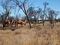
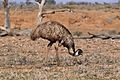
Fewer animals live in Australia's deserts compared to its coastal regions. The most common creatures are insects like termites and ants, which are very important for the desert's ecosystem. Other desert animals include wild camels, dingoes, large goannas (like the perentie), and many types of lizards and birds.
Mammals found here include bilbies, mulgara, common brushtail possums, and different kinds of wallabys and kangaroos. Some birds you might see are the rare Alexandra's parrot, wedge-tailed eagles, and emus. About 103 mammal species lived here before Europeans arrived, but 19 of them are now extinct. The survivors are mostly small rodents, bats, and marsupials. Wild camels are a big threat to desert plants.
Over 300 bird species live in the desert, including parrots, cockatoos, and owls. The desert is home to many lizards, such as the great desert skink and the thorny devil. Some animals, like the southern marsupial mole and the water-holding frog, survive by digging underground.
Australia's desert has more lizard species than almost anywhere else in the world, with over 40 different kinds. Fish, mussels, and insects live in the few permanent freshwater holes. For example, 34 fish species are found in Lake Eyre. Over 40 frog species have been seen after heavy rains.
The Dingo Fence was built to keep dingoes and wild dogs out of farming areas. Predators in the desert include dingoes and large monitor lizards like the perentie. Many introduced species (animals brought from other countries) have harmed Australia's desert wildlife and plants. Wild camels damage native plants because Australian desert plants didn't evolve with large grazing animals. Wild cats have also reduced the numbers of bilbies and mulgara.
-

The marsupial mole lives mostly underground.
-
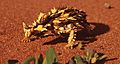
A thorny devil in the Northern Territory.
-
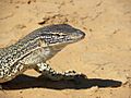
The Gould's monitor lizard is a large lizard found in the Australian desert.
-
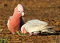
The galah lives in tree-covered savannas and open grasslands.
-
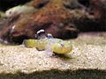
A desert goby fish.
-
Feral camels in Central Australia.
-
An emu in South Australia.
-
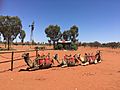
A camel farm near Uluru.
.jpg)


.jpg)
_(8692622586).jpg)

Climate of the Australian Deserts

Australia's climate is mostly shaped by hot, sinking air from a high-pressure belt. Dry conditions are often linked to a weather pattern called El Niño–Southern Oscillation. The types of plants in dry areas depend mainly on the soil.
The Australian desert gets about 81 to 250 millimeters (3 to 10 inches) of rain each year. This would normally be considered a semi-arid climate. However, a very high rate of evaporation makes it a true desert. Central Australia is very dry, with the driest parts getting only about 150 millimeters (6 inches) of rain annually. Thunderstorms are fairly common, with 15 to 20 per year.
Summer daytime temperatures range from 32 to 40 °C (90 to 104 °F). In winter, daytime temperatures average between 18 and 23 °C (64 and 73 °F), but it's warmer in the north. Frost is rare in the far north. In other parts, like the Tanami region, you might see a light frost or two each year. Away from the coast, winter nights can be quite cool compared to the warm days. Winter minimum temperatures drop to about 6 °C (43 °F) in most desert areas.
-
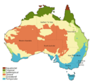
Climate zones in Australia, with deserts in orange and semi-deserts in yellow.
-
The number of rain days in the desert ranges from less than 20 to no more than 80 days per year.


Tourism in the Deserts
.jpg)
Tourism is a big industry in the Great Australian Desert. Government tourism groups promote Outback Australia as a popular place for both local and international visitors. They especially highlight nature-based and Indigenous-led experiences. For example, in 2015–2016, visitors spent almost a billion dollars on holidays in the Northern Territory alone. At places like Katjarra, there are camping spots and Indigenous rangers who can guide tourists.
Riversleigh in Queensland is a famous fossil site. It became a World Heritage site in 1994. This area has fossil remains of ancient mammals, birds, and reptiles that lived millions of years ago.
Some popular tourist attractions in the desert include:
- Arkaroola and Wilpena Pound in the Flinders Ranges
- Australian Stockman's Hall of Fame
- Devils Marbles
- Kakadu National Park
- Kata Tjuta (The Olgas)
- Katherine Gorge
- Kings Canyon (Watarrka)
- MacDonnell Ranges
- Monkey Mia
- Mount Augustus National Park
- Uluru (Ayers Rock)
- Willandra Lakes Region
- Lake Mungo
- Gawler Ranges National Park
- Gawler Ranges Conservation Park
- Great Victoria Desert Nature Reserve
- Lake Gairdner National Park
- Mamungari Conservation Park
- Munga-Thirri National Park
- Karlamilyi National Park
- Mount Willoughby Indigenous Protected Area
- Nullarbor Regional Reserve
- Pureba Conservation Park
- Queen Victoria Spring Nature Reserve
- Tallaringa Conservation Park
- Watarru Indigenous Protected Area
- Yellabinna Regional Reserve
- Yellabinna Wilderness Protection Area
- Yumbarra Conservation Park
- Black Rock Conservation Park
- Bon Bon Station Conservation Reserve
- Bunkers Conservation Reserve
- Caroona Creek Conservation Park
- Coongie Lakes Ramsar Site
- Danggali Wilderness Protection Area
- Ediacara Conservation Park
- Elliot Price Conservation Park
- Gawler Ranges National Park
- Hiltaba Nature Reserve
- Ikara-Flinders Ranges National Park
- Ironstone Hill Conservation Park
- Kanku-Breakaways Conservation Park
- Kati Thanda-Lake Eyre National Park
- Kinchega National Park
- Lake Frome Regional Reserve
- Lake Gairdner National Park
- Lake Gilles Conservation Park
- Lake Torrens National Park
- Mount Brown Conservation Park
- Mount Willoughby Indigenous Protected Area
- Munyaroo Conservation Park
- Mutawintji National Park
- Nantawarrina Indigenous Protected Area
- Pandappa Conservation Park
- Pinkawillinie Conservation Park
- Pualco Range Conservation Park
- Simpson Desert Regional Reserve
- Strzelecki Regional Reserve
- Sturt National Park
- The Dutchmans Stern Conservation Park
- Vulkathunha-Gammon Ranges National Park
- Wabma Kadarbu Mound Springs Conservation Park
- Whyalla Conservation Park
- Winninowie Conservation Park
- Witchelina Nature Reserve
- Witjira National Park
- Yalpara Conservation Park
- Yellabinna Regional Reserve
- Yellabinna Wilderness Protection Area
- Yumbarra Conservation Park
-
Lake Mungo National Park.
-
Uluru / Ayers Rock.
-
Millstream-Chichester National Park in Pilbara.
-
Munga-Thirri National Park in Queensland.


.jpg)


Mining in the Deserts
Besides farming and tourism, mining is the main economic activity in the huge, empty desert. Because the land has been stable for millions of years, the Outback is very rich in valuable minerals. It has large amounts of iron, aluminum, manganese, and uranium. There are also big deposits of gold, nickel, copper, lead, and zinc.
The value of mining in this large area is huge. Major mines include opal mines at Coober Pedy and Lightning Ridge. Metals are mined at Broken Hill and Olympic Dam. Oil and gas are found in the Cooper Basin. The Tanami Desert has gold mines like The Granites gold mine.
In Western Australia, the Argyle diamond mine is the world's largest producer of natural diamonds. The Pilbara region's economy is mostly about mining and oil. Most of Australia's iron ore comes from the Pilbara, which also has one of the world's biggest manganese mines.

Transport in the Deserts
.jpg)
The Outback has a network of old tracks, good paved roads, and well-kept dirt roads. The Stuart Highway runs north to south through the middle of Australia. A railway line runs parallel to it. There's a plan to create an "Outback Highway" by improving roads from the southwest to the northeast. This road would cross the continent diagonally.
Air travel is important for delivering mail in some areas because there are so few people and roads can close during wet seasons. Most mines in the Outback have an airstrip, and many workers fly in and out.
Roads in the desert include:
- Birdsville Track
- Burke Developmental Road
- Canning Stock Route
- Colson Track
- Connie Sue Highway
- French Line
- Gary Highway
- Gibb River Road
- Great Central Road
- Gunbarrel Highway
- Kalumburu Road
- Kidman Way
- Lasseter Highway
- Oodnadatta Track
- Peninsula Developmental Road
- Plenty Highway
- Sandover Highway
- Strzelecki Track
- Talawana Track
- Tanami Track
Towns in the Deserts
Even though the desert covers about three-quarters of Australia, only about 800,000 people live there. This is less than 5% of Australia's population. There are also about 1,200 small Indigenous communities, with almost half having fewer than 100 people. The Royal Flying Doctor Service (RFDS) started in 1928. It helps people who live in remote parts of Australia get medical care. Before the RFDS, serious injuries or illnesses often meant death because there were no hospitals or doctors nearby.
Young Indigenous adults from the Gibson Desert work in programs to keep their culture alive. Indigenous Australians in the desert regions include the Kogara, the Mirning, and the Pitjantjatjara. The number of Aboriginal people living in this region has been growing.
-
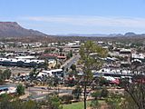
Alice Springs is a large town in the middle of Australia.
-
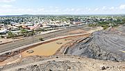
Port Hedland is a coastal town in Western Australia.
-
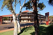
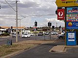
Broken Hill is a mining city in New South Wales, known as the "Capital of the Outback".
-
Port Augusta is a small desert city on the Spencer Gulf.

.JPG)


Some towns and cities in the Great Australian Desert include:
- Northern Territory
- Yulara
- Alice Springs
- Elliot
- Tennant Creek
- New South Wales/Victoria
- Western Australia
- Queensland
- South Australia
Languages and People
The Aboriginal languages with the most speakers in the desert today include Upper Arrernte, Walmajarri, Warlpiri, and the Western Desert languages. These include dialects like Yankunytjatjara dialect and Pitjantjatjara dialect. There is also the Adnyamathanha language in South Australia. Most of these languages belong to the Pama–Nyungan language family.
Some of the different Aboriginal groups living in the desert include the Kartudjara, Warumungu people, Pitjantjatjara, Panyjima people, Kuyani, Yankunytjatjara, Kunapa, Manjiljarra, Ayerrereng, Yuruwinga, Yulparija, and the Maduwongga.
-
An Aboriginal tribe in the Northern Territory.
-
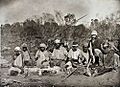
Frederic Bonney with an Aboriginal tribe.
-
Eastern Arrernte people in the Northern Territory.
.JPG)


See also
 In Spanish: Desiertos de Australia para niños
