Macumba River facts for kids
Quick facts for kids Macumba |
|
|---|---|

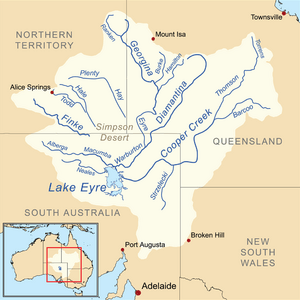
Map of the Lake Eyre Basin showing the Macumba River
|
|
| Native name | Maka-Wimpa, Ura-Ingka |
| Other name(s) | Treuer |
| Country | Australia |
| State | South Australia |
| Physical characteristics | |
| Main source | Macumba Hill 113 m (371 ft) |
| River mouth | Warburton River −12 m (−39 ft) |
| Length | 233 km (145 mi) |
| Basin features | |
| River system | Lake Eyre Basin |
| Basin size | 39,000 km2 (15,000 sq mi) |
| Tributaries |
|
The Macumba River is a special river in the far north of South Australia. It's known by different names by the local Aboriginal peoples: Maka-Wimpa in Arabana and Ura-Ingka in Arrernte. It was also once called the Treuer River.
The Macumba River is an ephemeral stream. This means it only flows after heavy rain, and sometimes it can be completely dry. It is an important part of the huge Lake Eyre Basin.
Contents
Where the Macumba River Flows
The Macumba River starts at the bottom of Macumba Hill. It gets bigger when the Alberga River, Hamilton Creek, and Currallulla Creek join it. From there, it flows towards the southeast.
The river then enters the Kalamurina Sanctuary. Finally, it empties into the Warburton River. This happens close to the northeastern side of Lake Eyre.
The River in a Dry Land
The Macumba River is located in a very dry area called the Simpson Desert. Because of this, the river flows only very rarely. Even when Lake Eyre fills up, like it did in 2010, most of that water usually comes from other places, like the Channel Country in Queensland.
The Finke River usually flows into the Simpson Desert, to the northwest of the Macumba. However, in the early 1900s, people thought the Finke River sometimes flowed directly into the Macumba. It is believed this happened in 1909, 1938, and 1945.
River System and Waterholes
The Macumba River is part of the western rivers system of the Lake Eyre Drainage Basin. Other rivers in this system include Peake Creek and the Neales River. This area has sandy plains, Acacia trees, and stony plains.
The river and its smaller streams cover a large area of about 39,000 square kilometers (15,000 square miles). The Macumba River has several waterholes that hold water for a long time, even when the river isn't flowing. Some of these are Ross waterhole, Walkinna waterhole, Tidnabucca waterhole, Ullabarracoola waterhole, and Christmas waterhole.
Eleven smaller streams, called tributaries, join the Macumba River. These include the Alberga River, Stevenson Creek, Coomparana Creek, and Yardaparinna Creek.
History of the Macumba River
The traditional owners of the land around the Macumba River are the Arabana and Arrernte peoples. They are both part of the Central Australian Desert language group.
Aboriginal Stories and Names
The Macumba River is important in the Emu story of the Aboriginal people. This story is very long, with 80 different parts.
The Arabana name for the Macumba is Maka-Wimpa. This means "fire track." The Arrernte name is Ura-Ingka, which also means "fire track." The river bed was named this because it would be the path that bushfires would follow in the area.
European Exploration and Development
John McDouall Stuart was the first European explorer to visit this area. He explored west of Lake Eyre in 1859. Later, in 1870, the Australian Overland Telegraph Line was being built. This telegraph line crosses the Macumba River near Oodnadatta.
Recent Floods
In 1984, the Macumba River, along with the Neales River and other western rivers, had a lot of water. This happened after heavy rains in central Australia. The water flowed into Lake Eyre South and partly filled Lake Eyre North. The river also flooded in both 2011 and 2012, with water reaching Lake Eyre each time.
 | Victor J. Glover |
 | Yvonne Cagle |
 | Jeanette Epps |
 | Bernard A. Harris Jr. |

