Neales River facts for kids
Quick facts for kids Neales |
|
|---|---|

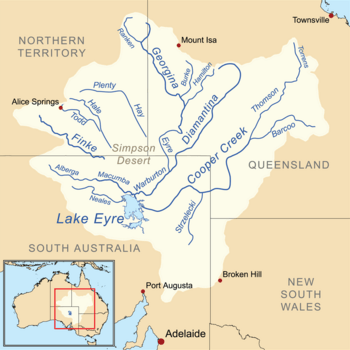
A map of the Lake Eyre basin showing Neales River
|
|
|
Location of the river mouth in South Australia
|
|
| Other name(s) | Neales Overflow |
| Country | Australia |
| State | South Australia |
| Region | Far North |
| Physical characteristics | |
| Main source | Mount Brougham Welbourne Hill 354 m (1,161 ft) |
| River mouth | Lake Eyre −1 m (−3.3 ft) 28°04′02″S 136°54′03″E / 28.0671°S 136.9007°E |
| Length | 420 km (260 mi) |
| Basin features | |
| River system | Lake Eyre Basin |
| Basin size | 35,000 square kilometres (14,000 sq mi) |
| Tributaries |
|
The Neales River is a special watercourse, or natural stream, found in the Far North part of South Australia, Australia. It's an important part of the landscape, especially because it flows into a famous lake.
Contents
Discover the Neales River
The Neales River is a tributary of Lake Eyre. This means it's a smaller river that flows into a larger body of water. Lake Eyre is a huge, usually dry, salt lake in the middle of Australia.
Where Does It Start and End?
The Neales River begins near Mount Brougham, which is close to a place called Welbourne Hill. This starting point is about 354 meters (1,161 feet) above sea level. From there, the river travels a long way, about 420 kilometers (261 miles).
Its journey ends when it reaches Lake Eyre. The mouth of the river, where it joins the lake, is actually below sea level, at about -1 meter. This shows how unique the geography of this area is.
How the River Got Its Name
The Neales River was named by a famous explorer named John McDouall Stuart. He named it after a man called John Bentham Neales. John Bentham Neales was an important person in South Australia's history. He was a successful businessman and also a politician. This means he helped make decisions for the government.
A Historic Crossing Point
Long ago, the original Ghan railway line crossed the Neales River floodplain. A floodplain is a flat area of land next to a river that might get flooded. The railway crossed over a special bridge called Algebuckina Bridge. This bridge was a big engineering achievement for its time. It helped trains carry people and goods across this wide, often dry, riverbed.
Part of the Lake Eyre Basin
The Neales River is part of a much larger area called the Lake Eyre Basin. This basin is a huge area of land where all the rivers and streams eventually flow towards Lake Eyre. It covers about 35,000 square kilometers (13,514 square miles). The basin is known for its dry, desert-like conditions, but when it rains, these rivers can flow strongly.
 | Claudette Colvin |
 | Myrlie Evers-Williams |
 | Alberta Odell Jones |


